|
||

|

|
|

|
Stock# 89412
Description
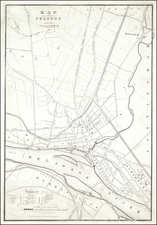
This unusual "map", dated 1846, offers a structured visualization of the political landscape of New Jersey during the mid-19th century. By detailing the representation of counties and their respective legislators, this piece shows the layout of the State Legislature as it stood in the middle of the 19th century.
Interestingly, the diagram does not list the parties of each politician. Nationally, party affiliation was certainly salient at this time, however in this context it does not seem particularly important to the maker.
Overall, this Diagram offers a clear view into the composition of New Jersey's Seventieth Legislative Assembly, highlighting the relationship between legislative members and their corresponding counties.
![[Revolutionary War Plans of New York, Boston, Charleston, Delaware River to Philadelphia & Havana] Various Plans and Draughts of Cities, Towns, Harbours &c . . .](https://storage.googleapis.com/raremaps/img/small/83450.jpg)
![[ Virginia / Maryland / Chesapeake Region ] Pas Kaart van de Zee Kusten van Virginia Tusschen C. Henry ent Hooge Land van Renslaars Hoek. . .](https://storage.googleapis.com/raremaps/img/small/47255.jpg)