|
||

|

|
|

|
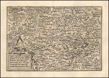
Fine, original antique two-sheet map of the region around Giessen, in the central German region of Hessen, just to the north of Frankfurt. This map was published in Paris by Jean de Beaurain in the mid-18th century.
The map shows the region in fine detail, with many cities, towns, roads, rivers, and other geographical features shown. Military positions, from France's recent 1759 foray into the region, are also shown. Positions are shown throughout, including just north of Giessen and to the west of Neustadt. French positions are in blue, and enemy positions are in red.
The map includes an inset in the lower right describing the hereditary nature of the Landgraviates of Hessen. On the right, there is a lengthy text description of the geography of the region. Below the map, Beaurain relays the manuscript sources from which he developed the map.
Jean de Beaurain was a French Geographer and Royal Geographer to King Louis XV.

![(Central Europe) Novissima Marchionatus Misniae Maximaeque Partis Voitlandiae Tabula [Newest map of the Margraviate of Meissen and the largest part of Voigtland]](https://storage.googleapis.com/raremaps/img/small/91160.jpg)