


|
||

|

|
|

|
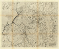
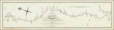
A Seminal Map of the American Southwest
Important early map of the Four Corners region, by Captain John N. Macomb, chief topographical officer in New Mexico.
In 1859, Captain Macomb was ordered to lead an expedition northward along the Old Spanish Trail to locate a route into Utah. John S. Newberry, who has served as geologist on a recent expedition with Joseph C. Ives the year before, accompanied the party. The results of Macomb's survey, Newberry's important geological report, and the illuminating map of the expedition, were not published until 1875. The map was engraved in 1864, but its official publication was delayed by the Civil War.
The major discovery of the expedition was the confirmation that the Green and Grand rivers unite to form the Colorado River, which flows into "the profound chasm of the Colorado Canyon," in Newberry's words, revealing to Newberry the drainage of the central part of the Far West. Macomb's map details these relationships for the first time, conveyed through the striking topographical renderings of Egloffstein.
Wheat refers to the map as a landmark, "because it is the first to show a trail to the junction of the Green and Grand. Second, because it is the culmination of Egloffstein's method of ruling maps and applying acid for varying times to convey the idea of altitude. And, third, because of the numerous trails of other explorers contained on it. It will stand for a long time as perhaps the finest map produced by this curious and revealing, yet evanescent, method."
A note at the bottom right credited to Baron F.W. von Egloffstein reads:
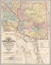
Central Gold Region
The Gold fields of four Territories, New Mexico, Colorado , Utah and Arizona, unite in the centre of the Map, comprising the Southern Portions of the various mountain ranges generally called the Rocky Mountains. Pike's Peak, Denver City, Colorado City, the Pogosa Mines, Animas mines, Dolores mines of Colorado Territory, the San Francisco mountain mines, the Coal beds of the Mesa La Vaca and the Big Cañon of the Colorado, a succession of deeply cut valleys, in places a mile in depth, in Arizona Territory. Santa Fe, Albuquerque and the old settlements of New Mexico, the mineral valleys of the Rio Grande del Norte and their fertile parks, are well known features. . . .
The names of the explorers are stated on the trails. . . .
The map is a superb rendition of the Four Corners area with tremendous detailing that includes Egloffstein's remarkable topography, well-known natural features, pueblos, explorers' routes, towns, and archaeological sites. An exciting document of a highly important expedition.
The map was issued in Macomb's rare Report of the Exploring Expedition from Santa Fe, New Mexico, to the Junction of the Grand and Green River, the text of which was produced in 1860 (the map in 1864), but not issued until 1876 due to the Civil War.
![A Map of Lewis and Clark's Track Across the Western Portion of North America, from the Mississippi to the Pacific Ocean. By Order of the Executive of the United States in 1804, 5 & 6. . . . [Complete with 3 volumes of Text: Travels to the Source of the Missouri River and Across the American Continent to the Pacific Ocean. Performed by Order of the Government of the United States, in the Years 1804, 1805, and 1806].](https://storage.googleapis.com/raremaps/img/small/81775.jpg)