|
||

|

|
|

|
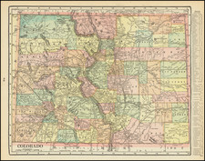
One of the Earliest Appearances of the Town of Columbia (now Telluride)
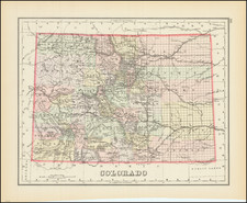
Fine large format map of Colorado, published by Rand McNally.
The map is exceptionally detailed and up to date, including information in Southwestern Colorado including the mining regions in Ouray County, San Juan County and the future San Miguel County which did not appear on contemporary maps by Thayer (1879) and Nell (1880). The map was likely published for distribution in the eastern markets and proved less commercially successful than the maps of Thayer and Nell.
This is an early state of the 1880 map, pre-dating the addition of Columbia (Telluride), San Miguel and Jennsion in San Juan County.
States of the Map & Rarity
The map is extremely rare. We note only a single example in a dealer catalog in the past 70 years (T.N. Luther, 1976) and before that Midland Books in 1951.
First issued in 1879, the map was also overprinted as a geological map in 1879, with later editions in 1880, 1881, 1887 and 1889.
OCLC locates examples of the 1880 edition at Yale, Denver Public Library, UT Arlington, Pike's Peak Library, Colorado College and University of Minnesota and Zurich University.
All editions are extremely rare. OCLC locates 1 example of the 1879 map and 1 example of the 1879 geological map, and 2 examples of the 1881 map.
Rand McNally & Co. is a large American map and navigation company best known for its annual atlases. The company got its start in 1856, when William Rand opened a print shop in Chicago. He was joined in 1858 by a new employee, Andrew McNally. Together, the men established their namesake company in 1868. Originally, the company was intended to print the tickets and timetables for the trains running to and through Chicago; their first railway guide was published in 1869.
By 1870, they had shifted from just printing to publishing directories, travel guides, and newspapers. Their first map appeared in 1872 in a railway guide. The map was produced using a new wax engraving method, a cheaper process that gave the company an edge.
By 1880 Rand McNally had entered the education market with globes, wall maps, and geography texts for students. In 1923, Rand McNally published the first Goode’s World Atlas, named after its editor, Dr. J. Paul Goode. For generations afterward, this would be the standard classroom atlas.
In 1899, William Rand left the company, but McNally and his family remained, controlling the company for over a century. In 1904, they published their first road map intended for automobiles and by 1907 were publishing Photo-Auto Guides, which combined photography and mapping to help drivers. In 1924, they produced the Auto Chum, a precursor to their famous road atlases. Rand McNally would remain the leader in road maps and atlases throughout the twentieth century.
In 1937, Rand McNally opened its first store in New York City. Ever on the frontier of technology, Rand McNally pioneered the scribing process for printing tickets in 1958 and printed their first full-color road atlas in 1960. Arthur Robinson developed his now-famous projection of Rand McNally in 1969. By the 1980s, the company was exploring digital reproduction and digital databases of maps for truckers. In the 1990s, they lead the charge to develop trip-planning software and websites. Today, most of its products are available online or in a digital format, including maps for tablets and phones.
![The Seasoned Traveler Goes By Train [Map of Denver and Rocky Mountain National Park]](https://storage.googleapis.com/raremaps/img/small/99861.jpg)
![[DeWitt Clinton Copy] An Account of Expeditions to the Sources of the Mississippi, and through the Western Parts of Louisiana, to the Sources of the Arkansaw, Kans, La Platte, and Pierre Jaun, Rivers During the years 1805, 1806 and 1807. And a Tour through the Interior Parts of New Spain. in the year 1807.](https://storage.googleapis.com/raremaps/img/small/81745.jpg)
![Indian Territory [with Colorado on verso]](https://storage.googleapis.com/raremaps/img/small/74706.jpg)