|
||

|

|
|

|
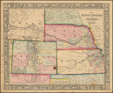
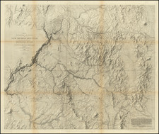
Detailed map of the area from Del Norte to Animas River, published by the United States Geological Survey.
Place names shown include Silverton, Howardville (Howardsville), Mt. Sneffels, Uncompaghre Peak, Mt. Wilson, San Miguel Lake, Engineer Mountain, Pigeon's Peak, San Cristoval Lake, Mineral Point.
The Hayden Survey of Colorado
The late 1860s and early 1870s saw four great surveys of the American West: the King Survey, which mapped the region around the 40th parallel; the Wheeler Survey, which attempted (unsuccessfully) to map the whole of the territories and western states at a moderate scale; the Powell Survey, which focused on the southwest and the Grand Canyon region; and finally the Hayden survey, which surveyed the territory of Colorado as well as the last great unmapped region of the Lower Forty-Eight: the Yellowstone Basin.
The Colorado survey was sandwiched between Yellowstone surveys and conducted in the years 1873-75. Hayden expected Colorado to soon become an important region because of the arrival of the railroads, and thus decided to expend enormous resources in order to create what would be one of the most extensive regional surveys anywhere in the world.
Each year, Hayden would subdivide his team into four groups, each consisting of a number of geologists, cartographic experts, and scientists, with each group assigned to a specific area. Hayden would always reserve the most interesting of the regions for himself: that is how he came to personally map the area around Aspen. The details of this survey are immensely interesting. Please refer to Thomas P. Huber's work, linked to in our references, for more information on the survey.
Ferdinand Vandeveer Hayden, known to the Sioux as "man-who-picks-up-stones-running," stands among the pantheon of eminent geologists of the 19th century.
Hayden's academic career commenced at Oberlin College, and he furthered his education at Albany Medical College, where he received his M.D. in 1853. Despite his medical training, Hayden was primarily engaged in geology, a field to which he would dedicate his life's work.
Hayden commenced his geological career with a survey in the Nebraska Territory in 1856. In 1859 and 1860, he conducted further exploratory work in the Rocky Mountains, particularly in Colorado, which was then part of the Nebraska and Kansas territories. His early work in the field earned him the respect of Native American tribes, with the Sioux reportedly dubbing him "man-who-picks-up-stones-running" due to his avid and energetic collection of geological samples during his expeditions.
By the 1860s, Hayden had risen to prominence as a geologist and was appointed the United States Geologist for the Geological Survey of the Territories. This role would define his career, leading numerous surveys in the Western United States. Notably, from 1871 to 1872, Hayden led a survey into the region that would become Yellowstone National Park, and his reports significantly contributed to the establishment of Yellowstone as the first National Park in 1872.
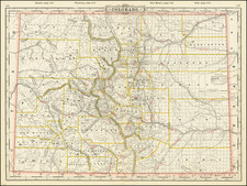
Hayden's most significant contribution to geological literature was the Geological Atlas of Colorado, published in 1877. This work was the result of comprehensive surveys conducted across Colorado, meticulously documenting the state's geography and geology. The atlas offered detailed maps on a scale previously unseen, encompassing not only Colorado but adjacent areas, including parts of Utah, Arizona, and New Mexico.
Hayden's influence extended to academia, as he was affiliated with the University of Pennsylvania for a period, where he held the position of professor of geology. His academic and field work combined to form a substantial body of knowledge that would be used by future scholars and explorers.
Ferdinand V. Hayden passed away on December 22, 1887, in Philadelphia, Pennsylvania. His enduring legacy is reflected in the numerous natural features named after him, including Hayden Valley in Yellowstone and Mount Hayden in Colorado. His contributions to geology during the 19th century remain a cornerstone of American geological and geographical sciences.
![[ Colorado ] Nell's New Topographical & Township Map of the State of Colorado - Complied from U.S. Government Surveys & other authentic sources Washington D.C. 1881](https://storage.googleapis.com/raremaps/img/small/101357dd.jpg)