


|
||

|

|
|

|
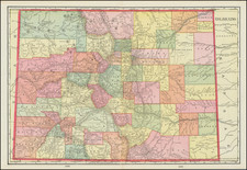
Important early map of Colorado Territory.
The map is noted by Carl Wheat as a highly polished work, making General Land Office maps of the previous two years look crude by comparison.
The map has been substantially redrawn based in part on the Ebert-Gilpin map of 1862, but not w/o a number of corrections. Grand or Bungarara River is shown on the Upper Colorado, Book Mtns is shown, and additional Park called Old Park is added to those on the Ebert-Gilpin and many new towns are added, including Laporte (Ft. Collins). The Road of Major Wyncoop in duty 1863 pursing the Ute Indian is shown from the Gunnison to the White and Bear (Yampa) Rivers. Berthoud's Wagon road to Salt Lake is derived from the Ebert Gilpin. Some early surveys near Denver and Colorado City are shown.
In the Plains, the Cheyennes and Arapahoes are noted, along with Fort Lyon and Fort Bend's, and Julesberg on the South Platte. There is evidence of Gold Mining and some of the mining towns and springs in the Rockies. Over a Dozen Peaks are named. Ft Carland is shown. In all, a remarkably detailed map, based upon the early surveys of the GLO, with the first map issued in 1861 and continuously improved thereafter.
![[DeWitt Clinton Copy] An Account of Expeditions to the Sources of the Mississippi, and through the Western Parts of Louisiana, to the Sources of the Arkansaw, Kans, La Platte, and Pierre Jaun, Rivers During the years 1805, 1806 and 1807. And a Tour through the Interior Parts of New Spain. in the year 1807.](https://storage.googleapis.com/raremaps/img/small/81745.jpg)

![[Colorado]](https://storage.googleapis.com/raremaps/img/small/85077.jpg)