|
||

|

|
|

|
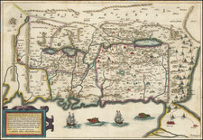
The Kingdom of Solomon
First edition of Phillipe de la Rue's scarce map of the Holy Land and contiguous regions.
The title "Regnum Salomonicum Seu Tabula digesta ad Libros Judicum Regum, Paral, et Prophetarum Per Eparchias XII, Mox Regna duo Auctore Phil. de la Rue" translates from Latin to "The Kingdom of Solomon, or a Map Arranged According to the Books of Judges, Kings, Chronicles, and Prophets, Through the Twelve Districts, Soon the Two Kingdoms, Author Philip de la Rue."
This antique map provides an intricate and historical representation of the Holy Land during the time of King Solomon, one of the most famed rulers in biblical history. The creator, Philip de la Rue, utilized scriptural texts including the Books of Judges, Kings, Chronicles, and Prophets to craft a cartographic depiction of the region.
The "Regnum Salomonicum" part of the title directly refers to the Kingdom of Solomon, Solomon being a biblical figure renowned for his wisdom and wealth. He reigned over the united Kingdom of Israel around the 10th century BC, succeeding his father, King David.
The phrase "Seu Tabula digesta ad Libros Judicum Regum, Paral, et Prophetarum" denotes that the map is arranged according to several key biblical books. The Books of Judges, Kings, and Chronicles along with the books of the Prophets form a significant part of the Old Testament, providing narratives about the history, leaders, and prophets of the Israelites.
"Per Eparchias XII" signifies the division of the Kingdom of Israel into twelve districts during Solomon's rule, an administrative division for economic and military organization. This division was not based on traditional tribal territories, but rather on resources and royal official responsibilities.
"Mox Regna duo" anticipates the eventual split of Solomon's united kingdom into two - the northern Kingdom of Israel and the southern Kingdom of Judah, which occurred after Solomon's death. This division played a significant role in the biblical narrative and the historical development of the region.
In summary, the map by Philip de la Rue presents a historical representation of the Holy Land during the biblical era of Solomon's reign. The title signifies the map's source of inspiration - the Old Testament, and its depiction of the Kingdom of Solomon's twelve administrative districts, the division into two kingdoms, and the historical and scriptural significance of these events.
![[Tribe of Judah] Tribus Iuda id est, pars illa Terra Sanctae quam in ingressu Tribus Iuda confecuta fuit](https://storage.googleapis.com/raremaps/img/small/82548.jpg)
![[Jonah Negotiating His Embarkation] Quid demens latebras circumspicis alterum in orbem. Si fugirs Dominum, non tamen effugies. Cui tellus paret, summus cui militat aether, Non parere putas huic etiam Oceanum](https://storage.googleapis.com/raremaps/img/small/85070.jpg)