|
||

|

|
|

|
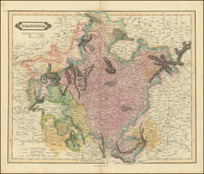
Fine, original antique map of the region around Frankfurt, in Germany. This detailed and extensive map was published in Paris by the Chevalier (Knight) Jean de Beaurain in the 1760s and includes important updates to the mapping of the region based on the experience of French engineers in the region.
The map shows Frankfurt and Mainz in the lower left, with the Rhine and Main River passing through the southern part of the map. The map stretches northwards to Giessen and Marburg. Forests, rivers, towns, hills, and much more are all shown.
The note in the upper left describes the genesis of this map. It describes how de Beaurain thought to use a previously-published map of the area, but realized that French surveyors who had been to the area disagreed with the previous map. As such, he reconciles the discrepancies in the present map.
Jean de Beaurain was a French Geographer and Royal Geographer to King Louis XV.
![[ Jülich Kleve ] De Hertochdommen Gulick Cleve Berghe en de Graeffchappen vander Marck en Ravensbergh . . . 1610](https://storage.googleapis.com/raremaps/img/small/99226.jpg)
![[ Duchy of Jülich] Iuliacensis Ducatus](https://storage.googleapis.com/raremaps/img/small/50126.jpg)