


|
||

|

|
|

|
Stock# 88052
Description
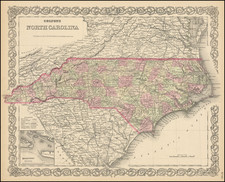
Cowperthwait's map of North Carolina, with insets of the Gold Region (centered on Cabarrus and Montgomery Co), the Neuse River and New Berne.
Shows towns, roads, railroads, rivers, mountains, lakes, creeks, canals, etc. Canals are noted in red. Rail lines and proposed rail lines are also shown.
The map was first issued by HS Tanner and appears in various formats until the late 1850s. The history of North Carolina and its counties from 1830 to 1860 can be tracked through the various editions of this map, as the plate is re-engraved by Tanner, Mitchell, Cowperthwait, Desilver, etc. Includes a table of distances and profile of the Dismal Swamp Canal.
![(Carolinas) Virginiae Partis australis, et Floridae partis orientalis, interjacentiumqus regionum Nova Descriptio [A New Description of the Southern Part of Virginia and the Eastern Part of Florida, and the Intervening Regions.]](https://storage.googleapis.com/raremaps/img/small/94131.jpg)

![Gray's New Map of North Carolina and South Carolina [Charleston Harbor Inset]](https://storage.googleapis.com/raremaps/img/small/98362.jpg)