![[ Prince Frederick Sound, Ketchickan, Queen Charlotte's Island & Stitka ] Cote Nord-Ouest de l'Amerique reconnue par Cape. Vancouver IVe. Partie . . . By George Vancouver](https://storage.googleapis.com/raremaps/img/small/90995.jpg)


|
||

|

|
|

|
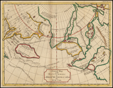
George Vancouver's Exploration: The Coastlines of Southwestern Alaska and British Columbia
Finely crafted map of the coastal regions explored by George Vancouver, covering Prince Frederick Sound in the north to Queen Charlotte's Island and includes the contiguous Pacific Coast of British Columbia (then called New Hanover) to the south. Notable areas such as Juneau, Sitka, Ketchikan, Princess Royal Island, and the regions of the Inside Passage are clearly demarcated, reflecting the depth of exploration and the thoroughness of the surveys conducted.
The routes taken by Vancouver in 1793 and 1794 are clearly shown, extending to include a passage north as far as the Keku Strait north of Prince of Wales Island, with numerous side trips into the protected sounds and waterways to the east.
Vancouver's expedition is recognized not merely for its discoveries but also for the detail with which the territories were charted. The map, with its precise depiction of coastlines and coastal topography, showcases Vancouver's rigorous approach to mapping. This chart is one among the sectional maps from the French edition of Vancouver's Voyages and holds significance as one of the first detailed printed portrayals of the areas explored.
Between 1792 and 1794, George Vancouver, aboard the British ships Discovery and Chatham, embarked on an extensive mission to map the northwest coast of North America, covering territories from Baja California to Alaska. Vancouver's lieutenant, Peter Puget (1765-1822), who first charted Puget Sound, played a crucial role in the expedition. Another prominent member of Vancouver's team was Joseph Baker, after whom Mount Baker was named.
Their journey was marked by detailed surveys and the naming of various landmarks. For instance, in April 1792, the crew explored and named Mount St. Helens and Mount Rainier, the latter after Vancouver's friend Rear Admiral Peter Rainier. By June 1792, Vancouver's team had explored and charted the intricate passages and coastlines of what we recognize today as the Strait of Georgia, Burrard Inlet, and Vancouver Island. Throughout the course of the expedition, Vancouver's interaction with local indigenous communities also enriched his maps, incorporating native names and knowledge into the documented territories.
One of Vancouver's significant achievements during this expedition was the clarification he provided on the geography of the Pacific. Through his detailed surveys, he dispelled the lingering notion of a navigable Northwest Passage existing in North America's upper latitudes. His work during these years not only filled gaps in the understanding of the Pacific coast but also laid a strong foundation for future navigational and cartographic endeavors in the region.
The Vancouver Expedition (1791-1795)
George Vancouver (1757-1798) was born in Norfolk and joined the Royal Navy in 1771. Only a year later, he sailed with Captain James Cook on his second voyage to the Pacific. Vancouver would also sail on Cook’s third, and last, voyage, the expedition during which Cook was killed in Hawai’i. Although he most likely made rough sketches while with Cook, Vancouver completed his first independent surveys while serving in the West Indies in the mid-1780s. Thanks to this work, his previous Pacific service, and the influence of a powerful patron, Vancouver was selected to lead a new expedition into the South Seas, one of the last large-scale exploratory voyages to the region.
Vancouver was ordered to sail under dual purposes. On the one hand, he was to represent the British at negotiations with the Spanish at Nootka Sound in the Pacific Northwest. The Sound was the subject of a territorial dispute between the empires that threatened to erupt into a larger conflict. Vancouver’s other, and main, purpose was to survey the southwest corner of Australia, Pacific islands, and the Northwest Coast of America. If possible, he was also to find a Northwest Passage.
Vancouver sailed in the Discovery, with the Chatham as escort, in April 1791. First, he made the Australian coast near Cape Leeuwin and surveyed a considerable extent of the southern coast. Next, he sailed to Tahiti and the Sandwich Islands. Then, Vancouver and his crew charted the coast from near San Francisco all the way to Alaska. En route, at Nootka, Vancouver met with his Spanish counterpart, Bodega y Quadra; the island where they negotiated was initially named Quadra and Vancouver Island, for both men. They decided they could not interpret the instructions they had been given and referred the matter back to diplomats in Europe for further study. He then completed three surveying seasons on the Pacific Northwest Coast, with winters in Hawai'i.
Vancouver returned to England via Cape Horn in September 1795, over four years after he had led one of the longest surveying voyages in history. He was promoted to the rank of post captain but the voyage ruined his health and he retired upon return to shore.
He turned his energies instead to producing an authoritative account of his voyage, complete with detailed charts, as the Admiralty had ordered. Vancouver died in May of 1798. He had completed nearly all of the account, half a million words in length, but it still lacked roughly 100 pages. After George’s death, his brother, John, along with Lieutenant Peter Puget, for whom Puget Sound is named, and Lieutenant Baker finished the work. It was published in 1798 in three quarto volumes and accompanied by a folio atlas. A French edition followed in 1799-1800, with another English edition in 1801.
George Vancouver (1757–1798), a naval officer and explorer, grew up in King’s Lynn, England, the youngest of six children. After entering the Royal Navy in 1771, he served in both the second and third great exploratory voyages of James Cook. During Cook’s second voyage, a three-year quest to find a legendary southern continent, Vancouver received instruction from the astronomer William Wales. During Cook’s third voyage, to the Pacific Northwest, Vancouver was part of the first known group of Europeans to land on the coast of present-day British Columbia.
Vancouver gained valuable navigational, surveying, and mapping experience in the Pacific Northwest during his time with Cook. After returning from Cook’s third voyage in 1780, Vancouver was promoted to lieutenant and spent the following nine years serving on fighting ships, primarily in the Caribbean.
In 1790, Vancouver was chosen to captain the Discovery and charged with a mission to discover and chart the vast areas of the Pacific that were still unknown, in part to locate a Northwest Passage between the Atlantic and Pacific Oceans. This four-year voyage of discovery circumnavigated the globe and eliminated the possibility of an inland Northwest Passage. During many months of surveying, Vancouver produced detailed regional maps of the Northwest Coast, as far north as Alaska. He also established several hundred place-names for physical features in the areas surveyed.
Upon returning to England in 1795, Vancouver’s voyage received little recognition, and he faced personal and political attacks from colleagues and crew members alleging abuse of power. With his health failing, Vancouver spent his remaining years in retirement, revising his journal for publication. His Voyage of Discovery to the North Pacific Ocean, and Round the World was first published in 1798, which was also the year of his death. It contained a multi-volume account of his voyage as well as an atlas of his maps. His exploration and mapmaking activities greatly increased knowledge of the North American coast.
![Carte des nouvelles decouvertes dresseee par Phil. Buache… [with] Extrait d'une Carte Japonoise de l'Univers apportee en Europe par Kaempfer . . . [Bay of the West]](https://storage.googleapis.com/raremaps/img/small/84038.jpg)
![Asie . . . 1650 [with unusual depiction of the West Coast of North America and the Island of Corey]](https://storage.googleapis.com/raremaps/img/small/102556.jpg)