|
||

|

|
|

|
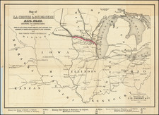
Fine example of the first state of John Cary's map of the Western Territory and Great Lakes regions, from his New Universal Atlas.
The map is most noteworthy for its detailed treatment of The Western Territory, which was then bounded by the Mississippi River in the West, Kentucky in the South, the Ohio River, Lake Erie and Lake Huron in the east, and Lake Superior in the North, It covers the region which would become Ohio, Indiana, Illinois, Michigan, Wisconsin, part of Minnesota, and Iowa. This region includes the location of the Chippeway, Monomonis, Winebagos, Ootagamis, Macootens, Illinois, Weautenaus, Pootewatomis, Ootaways and other Indian Tribes, and the lands of the Illinois Company, Jersey Company, Wabash Company, and other early American commercial ventures.
The 1795 Treaty of Grenville Line is shown along with other notes regarding travel and portages. Many early forts are located, as are notes regarding wild fowl above the Upper Iowa villages on the Mississippi, a cave north of St. Louis and a host of important early roads. Too many interesting annotations and early placenames and notes to list. The treatment of the Missouri River prior to the return of Lewis & Clark and the detail in Kentucky are also notable.
An excellent map for Midwest and Great Lakes collectors.
John Cary (1755-1835) was a British cartographer and publisher best known for his clean engraving and distinct style which influenced the entire map industry. Born in Wiltshire, John was apprenticed to an engraver in London. He started his own business by 1782 and moved to several premises before settling at 86 St James’s Street in 1820.
Cary had several significant collaborations during his career. John Wallis and Cary diversified Cary’s business to include broader publishing projects. Brother William and John made globes together, while brother Francis participated in the company’s engraving work. Finally, geologist William Smith and Cary developed and sold geological maps, some of the first of their kind. The pair also produced a notable series of county maps starting in 1819. Cary’s atlases, of English counties and the world, were the standard texts of the early nineteenth century. He was appointed surveyor of roads to the General Post Office in 1794, which led to the New Itinerary, first published in 1798.
John trained his son, George, in engraving and George and his other son, John Jr., took over the business in 1821. It was then known as G. and J. Cary and continued in trade until 1850. The firm’s materials were then acquired by George Frederick Cruchley and then Gall and Inglis. By the time John died in 1835, Cary was the authoritative name in private map publishing and his business was a leader in the field throughout the first half of the nineteenth century.

![[Vancouver] Fraser River and Burrard Inlet](https://storage.googleapis.com/raremaps/img/small/68029.jpg)