This item has been sold, but you can enter your email address to be notified if another example becomes available.


|
||

|

|
|

|
Stock# 87387
Description
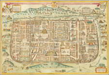
Uncommon 18th-century map of Jerusalem, showing the city from the south and published by Thomas Bowen in London.
The map shows Jerusalem in great detail as it stood during ancient times, with monuments such as pilate's house, the Temple of Solomon, and the Beast Market. Adjacent to the town are Calvary, with its three crosses, and the olive gardens to the east. A plan in the lower right shows a plan of what a generic "great house" would have looked like at the time.
The engraving shows particular attention to detail and presents the city beautifully. This map was published as part of Edward Kimpton's A new and complete universal history of the Holy Bible, including the Old and New Testament, issued during the latter half of the 18th century.
Condition Description
Nice, dark impression. Some toning, foxing, and staining. Black ink stamp "21637" in the lower margin.
![[Historical Time Line Map -- Creation To 100 AD] Tableau de L'Histoire Sainte Depuis La Creation du monde jusqu'a la dispersion du Juifs . . .](https://storage.googleapis.com/raremaps/img/small/82069.jpg)
![[ Jerusalem ] Die Heilige Statt Jerusalem Contrafehtet nach Form und Gestalt wie sie Ietz Erbauwen ist](https://storage.googleapis.com/raremaps/img/small/88642.jpg)