


|
||

|

|
|

|
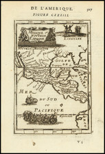
Fabulous promotional map of Florida, issued during the second British invasion in the 1880s. Central Florida underwent a British invasion in the 1880s. Governor William Bloxham's sale of four million acres of land to Hamilton Disston, a Philadephia industrialist, in 1881 launched a second, albeit unofficial, English period in Florida history. Within a year, Disston had sold half of his holdings to Sir Edward Reed. Reed, a British capitalist, proposed to develop Central Florida as an investment opportunity for English and European entrepreneurs. Reed and his friend Jacobus Wertheim organized the Florida Land and Mortgage Company, which aggressively marketed Florida land in England and on the European continent. Advertisements (such as the present map) describing the rich possibilities present in central Florida regularly appeared in English newspapers throughout the 1880s and 1890s. Publicists told prospective buyers that Florida was a place where pleasurable surroundings, commercial opportunity and a healthy climate combined to create a veritable paradise. This highly detailed promotional tract is dividied into townships, with the townships in red owned by the Investment group and the train lines plainly delineated. A smaller inset shows the railway lines and steamship connections in the Southwest. The map is apparently very rare, having not appeared in a dealer catalogue in the past 25 years. Archivally backed, with minor loss at the folds and a bit of staining.
G. W. & C. B. Colton was a prominent family firm of mapmakers who were leaders in the American map trade in the nineteenth century. The business was founded by Joseph Hutchins Colton (1800-1893) who bought copyrights to existing maps and oversaw their production. By the 1850s, their output had expanded to include original maps, guidebooks, atlases, and railroad maps. Joseph was succeeded by his sons, George Woolworth (1827-1901) and Charles B. Colton (1831-1916). The firm was renamed G. W. & C. B. Colton as a result. George is thought responsible for their best-known work, the General Atlas, originally published under that title in 1857. In 1898, the brothers merged their business and the firm became Colton, Ohman, & Co., which operated until 1901, when August R. Ohman took on the business alone and dropped the Colton name.
![(The First Letter From British Florida) [September 5, 1763, Autograph Letter, Signed, from Robert Campbell to John Campbell, 4th Earl of Loudoun, describing the British taking possession of Florida and the state of the settlement of Pensacola]](https://storage.googleapis.com/raremaps/img/small/86620.jpg)