|
||

|

|
|

|
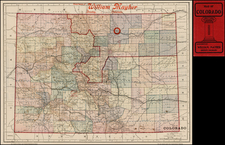
Emory's Map of the Transmississippi West.
Marvelously detailed map of the Western Territorial US, published by W.H. Emory in his Report of the United States and Mexican Boundary Survey.
The map is one of the fundamental post-Gadsden Purchase maps of the West. It shows the US Boundary with Mexico and tracking both the pre- and post-Gadsden demarcations. The unexplored lands of Arizona, New Mexico, Nevada and Utah are prominently labeled. Many early roads and forts are shown, especially in the western parts of Texas and along the Missouri and its tributaries.
Massive Nebraska and Kansas Territories dominate the Plains, immediately prior to the discovery of Gold in Colorado in 1858. The route of the Yellowstone River is still relatively unexplored and the region between the Missouri and Wind Rivers largely unknown, other than the Black Hills. The region between the Cascades and the Bitter Root Mtns are similarly unknown. The Upper Colorado includes nice topographical detail, as do the Wasatch and Elk Mtn Ranges. Lake Tahoe is shown, but the Tetons and Yellowstone Lake have not been discovered.
An essential map for Western Americana collectors, providing one of the best and most detailed compilations of geographical information prior to the western state surveys by the GLO.
Martin & Martin note that the map shows the vast information accumulated since the Treaty of Guadalupe Hidalgo…documenting the West as it was actually known.