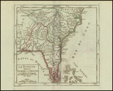
|
||

|

|
|

|
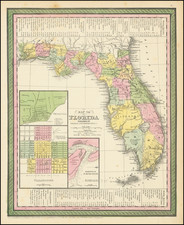
Remarkable large format map of Florida, issued only in the later post-Civil War editions of Colton's Atlas. The County configurations are still primitive, especially in the South. Early railroad lines appear, as do many of the US Government Forts established throught the state. The second edition of the map, first issued in 1868. A good example with a partially repaired fold split and one or two minor marginal tears.
G. W. & C. B. Colton was a prominent family firm of mapmakers who were leaders in the American map trade in the nineteenth century. The business was founded by Joseph Hutchins Colton (1800-1893) who bought copyrights to existing maps and oversaw their production. By the 1850s, their output had expanded to include original maps, guidebooks, atlases, and railroad maps. Joseph was succeeded by his sons, George Woolworth (1827-1901) and Charles B. Colton (1831-1916). The firm was renamed G. W. & C. B. Colton as a result. George is thought responsible for their best-known work, the General Atlas, originally published under that title in 1857. In 1898, the brothers merged their business and the firm became Colton, Ohman, & Co., which operated until 1901, when August R. Ohman took on the business alone and dropped the Colton name.
![[Rare Blaeu West Indische Pascaert Wall Map Section] Insulae Americanae in Oceano Septentrionali, cum terris adjacentibus](https://storage.googleapis.com/raremaps/img/small/75672.jpg)
![[War of Jenkins Ear in Florida and West Indies] [Harbors, Towns & Fortresses of North America, St. Augustine, Providence (Grand Bahama Island), Porto Antonio (Jamaica), Havana, Santiago (Cuba), Kingston, and Antiqua)]](https://storage.googleapis.com/raremaps/img/small/75642.jpg)

![[Florida Indians / Hermaphrodites] Hermaphroditorum officia. XVII.](https://storage.googleapis.com/raremaps/img/small/97966.jpg)