This item has been sold, but you can enter your email address to be notified if another example becomes available.


|
||

|

|
|

|
Stock# 86703
Description
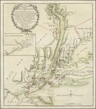
Detailed time table map of the routes of the New York, Central and Hudson River Railroad, dated March 26, 1882.
The map shows the railroads operating between the midwest and plains states to New York and the east coast. Highlighted in darker black lines is the route of the New York Central, extending from New York City northwards along the Hudson River towns of to Albany and Troy, then west to Buffalo and connections on Lake Ontario and Lake Erie.
At the far right is a list of diferent express companies and local connections.
The verso includes numerous time tables for the various lines illustrated on the map.