The item illustrated and described below is sold, but we
have another example in stock. To view the example which
is currently being offered for sale, click the
"View Details" button below.


|
||

|

|
|

|
Stock# 86649
Description
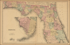
Detailed antique map of Florida, published by O.W. Gray & Sons.
The map is colored by county and shows towns, township surveys, forts, swamps, lakes, rivers, railroads, roads, post offices, stations, etc. Large inset of the Keys and Monroe and Dade counties. Lake Worth is shown in the inset, with no towns labeled nearby.
One of the best commercial atlas maps of Florida of the era. From one of the leading American map publishers of the 1870s and '80s.
Condition Description
Original hand-color by county. Foxing, moderate in centerfold.
O.W. Gray Biography
O. W. Gray was a publishing firm based in Philadelphia. Later, they published as O. W. Gray & Son. They published atlases in the late nineteenth century. Gray's National Atlas was one of the most successful commercial ventures of the 1870s and one of the last to employ hand coloring on maps.
![[ Charleston, Boston, New York, St. Augustine, Bahamas, etc ] Particular Draughts of some of the Principal Towns and Harbours belonging to the English French and Spanish in America and the West Indies.](https://storage.googleapis.com/raremaps/img/small/102804.jpg)
![[ Atlas of The United States ] Karte von Amerika](https://storage.googleapis.com/raremaps/img/small/84353mp2.jpg)