|
||

|

|
|

|
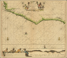
Portolan Chart Produced in the Workshop of One of the Two Dynastic Chartmaking Families of Renaissance Europe
Fascinating hand drawn and painted portolan sea chart of the Eastern Atantic Ocean, Western Europe, North Africa and the British Isles, created in the workshop of Franciscus Oliva II, a member of one of the two most enduring chartmaking families of the Renaissance.
The chart extends from the Azores, Madeira, and Canary Islands in the west to the British Isles in the north. The Balearics, Iberian Peninsula and westernmost Mediterreanean are at the center, with the Mediterranean coast of Africa extending to the area around Algiers and the Atlantic coast covering Morocco and most of Western Sahara.
The chart is embellished with an elaborate coats of arms for France (in the Atlantic) and Spain, along with an Ottoman coat of arms in North Africa, There are nine compass roses, two scale bars, a crowned armorial shield of the Ottoman Empire, and several palm trees.
Franciscus Oliva, also known as François Ollive and Franciscus Caloiro Oliva was active in Marseilles from about 1643 to 1666. A member of the "Oliva and Caloiro e Oliva" Dynasty, which dates back to Palma de Mallorca (Bartomeu Olives) in 1538, the family played one of the most active roles in the creation of portolan charts between the 1530s and the 1670s, with Astengo identifying no less than fourteen family members on maps over the period. Astengo notes that the "oldest extant work by François Ollive of Marseilles is a five-sheet atlas that bears the inscription 'Franciscus Oliva me fecit in civitate Marsiliae anno 1650." His works are among the most ornately decorated of the period, but he also "took pains to keep his work up to date."
While the present work is unsigned, the embellishments are stylistically characteristic of the work of Franciscus Oliva. The MEDEA project website identfies one hundred examples of his work, of which we have compiled the following list which illustrate the stylistic similarities.
- 1650: https://medea.fc.ul.pt/view/chart/6195
- 1652: https://medea.fc.ul.pt/view/chart/6218
- c.1660: https://medea.fc.ul.pt/view/chart/5902
- 1661. https://medea.fc.ul.pt/view/chart/5523
- c.1662: https://medea.fc.ul.pt/view/chart/5238
This example bears evidence of a single horizontal fold, suggesting that it was part of a multi-sheet portolan atlas. The most recent example of a Franciscus Oliva portolan atlas (ten charts) to come to market sold at Aguttes on June 16, 2018 for 260,000 Euros (Lot 23 - about $300,000 USD).
The present example, while in only a fair condition, remains a remarkable artifact of the portolan chartmaking tradition, which dates back to at least the middle of the thirteenth century.
![[Bristol Channel] Carte Particuliere du Canal de Bristol ou Embouchure de la Severne Redigee au Depot de Cartes et Plans de la Marine . . . l'An Vi de la Republique](https://storage.googleapis.com/raremaps/img/small/85130.jpg)