|
||

|

|
|

|
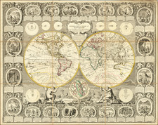
Drawing the World and the Latest Discoveries by Hand
Remarkably fine, hand-drawn double-hemisphere map of the world with many ships’ tracks from the latest exploratory voyages.
The map is based on an unknown precursor, but it is remarkably similar to the 1781-1784 states of Samuel Dunn’s world map, “Scientia Terarum et Coelorum,” which was first issued in 1772 and periodically revised until at least 1794. However, the map shows further improvements in the Arctic regions, most notably information from MacKenzie's explorations.
Hand-drawn maps were often completed as educational activities, for both girls and boys, in this period. Dunn was a renowned geography teacher, so the likelihood that his maps would be used for such an activity is high. While carefully delineated, this example appears to be not quite finished, as the ships’ tracks are not labeled.
The continents are delicately drawn, with the southern portion of New Holland completed with a dotted line—it would not be charted fully until the first years of the nineteenth century. There is no southern continent.
Ships’ tracks criss-cross the waters; three of them are the voyages of James Cook (1768-1771, 1772-1775, 1776-1780). Thanks to these voyages, Aotearoa/New Zealand is shown completely, as is the east coast of Australia and Hawai’i. The latter, here written as Owhyhee, includes a note marking the location of Cook’s death.
Other routes marked on the map include that of Jean-Baptiste Charles Bouvet de Lozier (1738-9), who saw Cap de Circoncision in the far southern Atlantic Ocean. It was the first time that land had been spotted south of the 50th parallel south. The cape is marked here with an unfinished coast, but not labeled.
Also included is the track of the Frenchman Louis Antoine de Bougainville, who led his own circumnavigation (1766-1769). He called at Tahiti weeks after the British Captain Samuel Wallis and found it idyllic. His description of the island would do much to create the stereotype of the Pacific as an exotic paradise to Europeans.
A less well-known voyage appears to sail up the west coast of New Holland. This is the route of Louis Aleno de St Aloüarn, a French naval officer. St Aloüarn, along with Yves de Kerguelen, sailed to Mauritius in 1771. They then went across the Indian Ocean. Kerguelen spotted a large mountain that he thought was Australia; the island is now named for him and is labeled on this map. St Aloüarn made it to the New Holland coast and sailed northward, claiming it for France, although the claim was never recognized.
The Manila-Acapulco galleon route
The Spanish galleon San Carlos traces a line across the Pacific. In the sixteenth century, the Spanish were expanding their empire around the globe. They had invaded and taken control of vast parts of South America and also had a strong presence in the East Indies. Ferdinand Magellan, sailing under the Spanish flag, arrived in the Philippines in 1521. He was killed on the island of Cebu. For the next forty years, Spanish expeditions attempted to colonize the islands. In 1564 Miguel López de Legazpi command a squadron destined for the Philippines. One of his men, Andrés de Urdaneta, set out east toward New Spain and managed the first known crossing of the Pacific from west to east.
After Urdaneta’s voyage, an annual trade began which brought silver from New Spain and South America west to Asian markets. These galleons docked at Manila to offload their bullion and take on Asian trade goods destined for Latin America. The Manila-Acapulco galleon route lasted from 1565 until 1820 and involved 120 ships (112 built in the Philippines, 8 built in Mexico). These ships varied in size—the Covadonga was a vessel of 700 tons—but the largest were the greatest ships afloat at the time, averaging between 1,700 and 2,000 tons. However, the passage was a dangerous one, even for such formidable ships. Over thirty vessels were lost, including several to British privateers and naval vessels. Thomas Cavendish captured a Manila galleon in 1587, and Woodes Rogers overcame a galleon off the coast of Mexico in 1709. A third, and the most famous, galleon raid took place in 1743, that of Anson and the Covadonga.
Anson’s expedition and the capture of the Covadonga
Anson’s track also crosses the Pacific on this map. In 1739, resentment over Spanish raids of British ships in the Caribbean sparked the War of Jenkin’s Ear, which would widen into the larger War of Austrian Succession. The Commissioners of the British Admiralty planned a global strategy to harass Spanish trade and weaken its over-stretched navy and merchant marine. Anson’s voyage was part of this strategy. He set out in 1740 with a squadron of six ships and 1,900 men.
By 1743, Anson had crossed the Pacific after raiding the west coast of South America. Prior to crossing he had waited off the Mexican coast for the Acapulco galleon, full of silver, to appear, but he only succeeded in blocking the ship from leaving port. Meanwhile, he had also lost five of his ships and 1,400 of his men, primarily to scurvy; only his own ship, Centurion, remained intact. After repairing at Macao, Anson let Chinese officials know that he was headed for Britain; in reality, he sailed to the Philippines to await the entrance of the Acapulco galleon. Remarkably, considering the voyage prior to that point, the Centurion took the Nuestra Señora de la Covadonga with only light casualties.
Anson returned home rich and quickly became famous as well, a bright spot in an otherwise dismal war devoid of triumphant victories. Named a Commissioner of the Admiralty, Anson set about arranging the publication of his experiences in the Pacific. Published in 1748, the account was immensely popular and the story of Anson found its way onto maps and globes like this one.
Rarity
Hand drawn maps of this size and quality are very unusual.
Cook's first voyage (1768-1771)
The Transit of Venus is one of the rarest predictable astronomical phenomena, occurring twice in eight years and then not again for over one hundred years (in a 243-year cycle). Observing the time it takes for Venus to transit across the sun can help to calculate the size of the solar system and the distance from the Earth to the Sun. In 1761, scientific societies sought to record the Transit from posts around the world. However, many of the observations were flawed or thwarted by the weather, especially those arranged, in haste, by the Royal Society of London. Determined to not repeat the same mistake, the Royal Society planned a South Sea voyage to view the 1769 Transit in concert with the Royal Navy, as the southern Pacific would be one of the places where the Transit was visible.
The Admiralty chose Lieutenant James Cook to command the expedition, based on his aptitude for charting and instrumentation. He was joined by Joseph Banks, a wealthy young botanist, and his retinue of scientists and artists. In addition to observing the Transit, Cook was secretly instructed to seek out and claim any potentially-useful territory or resources that his ship, Endeavour, came across.
Cook and his crew sailed from Plymouth on August 25, 1768. It sailed south, to Tierra del Fuego, and then to its destination for the Transit: Tahiti. There, three groups observed the Transit, although their results were imprecise. When the Endeavour left Tahiti in July 1769; on board was a new member of the party, the Rai’aitean priest and navigator Tupaia, along with his servant, Taiato.
The ship headed south, arriving in New Zealand in early October. There, Tupaia found that he could understand and speak with the local people, the Māori. However, this did not prevent several violent incidents that resulted in deaths. While charting the coastline, Cook and the voyage astronomer, Charles Green, observed the Transit of Mercury. The ship sailed round the southern tip of the South Island, proving it was not connected to a southern continent.
Next, the Endeavour set out east, encountering the east coast of Australia in April 1770. They were the first Europeans to do so. After stopping at a place they called Botany Bay, the ship turned north, skirting the coast. Endeavour ran aground on the Great Barrier Reef; while the ship was saved, they had to stop for repairs at Waalumbaal Birri, or Endeavour River. Here, the Europeans saw their first kangaroo and learned its name from the local people, the Guugu Yimithirr. They nearly ran aground again, but narrowly averted disaster and made for Jakarta, then known as Batavia.
In Batavia, many members of the crew became ill. More than two dozen men, including Sydney Parkinson, the voyage artist, the aforementioned Charles Green, and Tupaia, died in Jakarta or at sea soon thereafter. Weakened, the Endeavour called at the Cape of Good Hope and returned to the Thames in July 1771.
Cook's second voyage (1772-1775)
Cook’s first voyage was considered a success. The Admiralty chose to send him to the Pacific again, this time to focus on finding and charting Terra Australia incognita, if it existed. This time, Cook was in command of the Resolution and accompanied by the Adventure, captained by Tobias Furneaux.
The ships departed Plymouth on July 13, 1772. They made for the Cape of Good Hope and then sailed south, in search of land. They reached an ice sheet and could not find a break to sail through. The crew melted ice for fresh water and the expedition artist, William Hodges, drew eerie pictures of looming icebergs. On January 17, 1773, the ships crossed the Antarctic Circle, the first ships known to have done so.
Separated in fog, the ships headed toward New Zealand. They rendezvoused in Queen Charlotte Sound, where they traded with the Māori. The Māori inquired as to location of Tupaia and were sad to hear that he had died.
The ships returned to Tahiti, where they found the politics of the island had shifted and there was a new leader, Tu, to consult. Mai, a Rai’atean man, joined the Adventure, while Hitihiti joined the Resolution. The former became the first Polynesian to visit Britain, while Hitihiti returned home after sailing to Tonga, the Antarctic, New Zealand, and Easter Island.
Cook and his men next sailed to Tonga and then back to New Zealand. En route, the ships were separated again. Resolution left for southern waters without Adventure; Furneaux decided to return to Britain, leaving Cook in the Antarctic.
In December 1773 and January 1774, Resolution crossed the Antarctic Circle for the second and third times. They reached 71°10’ South, the farthest south any ships had sailed; the record would stand until 1823. He had decidedly proven that the great southern continent was nothing more than a myth.
Returning north, Cook called at Rapa Nui, or Easter Island, and his men marveled at the Moai, large statues that stand guard on the island. The Resolution returned to Tahiti, and then called at Niue, Nomuka, Vanuatu, New Caledonia, and Norfolk Island. After another visit to New Zealand, they sailed east to Tierra del Fuego. In the Atlantic, Cook named South Georgia and the South Sandwich Islands. On the homeward stretch, Resolution visited St. Helena and then anchored in Portsmouth on July 30, 1775.
Cook's third voyage (1776-1780)
After two Pacific cruises that observed the Transit of Venus, charted New Zealand, the eastern coast of Australia, and many islands; and disproved the existence of a vast southern continent, Cook’s third voyage focused on searching for the Northwest Passage. It was also tasked with the return of Mai, a Ra’iatean man and the first Polynesian visitor to Britain, who had joined Cook’s second voyage.
Cook in the Resolution was joined by Charles Clerke in the Discovery. Resolution sailed in July from Plymouth, rounded the Cape of Good Hope, visited the Kerguelen group in the Southern Indian Ocean, then called at Tasmania before heading to New Zealand.
In the spring of 1777, the ships sailed north, first to Tonga, and then to Tahiti. They left Mai on Huahine in a wooden house built for him by the crew. Cook continued north and became the first European to encounter the Hawaiian Islands, in January 1778.
During the warm months (in the northern hemisphere) of 1778, Cook and his crew charted the northwestern coast of North America, calling at Nootka Sound and Prince William Sound. They went up the Cook Inlet, which they thought could be a Northwest Passage, but it proved to be a false start. Heading west, they skirted the Aleutians and sighted the Asian coast. In January 1779, they returned to Hawai’i to resupply and rest.
In Kealakekua Bay, Cook was greeted warmly by the Hawaiians. They stayed for three weeks, enjoying the considerable hospitality of the people. In early February, the ships set out for another northern tour, but only a few days from Hawai’i the Resolution’s mast was damaged, forcing their return.
This time, they were not welcomed by crowds. During a dispute over a stolen boat, a scuffle broke out. When it was over, sixteen Hawaiians, four marines, and Cook were dead.
Clerke took command. He forced the Hawaiians to give him Cook’s remains, which were buried at sea. He then led the ships north, passing through the Bering Strait before turning back due to ice. In August of 1779, Clerke too died, of consumption, while near Kamchatka. A third commander, John Gore, then had to lead the ships home.
The ships sighted Japan on their southward journey before calling at Macao. There, they made sizeable profits by selling sea otter pelts, kickstarting a new industry. By April 1780, the Resolution and Discovery were back at the Cape of Good Hope. They returned to Britain via the Orkneys, anchoring in the Thames on October 7, 1780.
Samuel Dunn (bap. 1723-1794) was a teacher of mathematics and navigation who published, among other things, maps and charts. Although information about his early education is lacking, by age nineteen he was leading his own school and teaching writing, accounting, navigation, and mathematics in Devon. In 1751, he moved to London, where he taught in several schools and tutored privately.
By the 1760s, Dunn was known as a respected astronomer and had published a range of textbooks on math, navigation, and astronomy. After the publication of the Nautical Almanac, Dunn acted as a certifier of ships’ masters under the new system, on behalf of the Board of Longitude. He performed similar work for the East India Company, as well as made charts of the East Indies. In 1776 he published A New Variation Atlas and, in 1777, A New Epitome of Practical Navigation, or, Guide to the Indian Seas. By 1780, he was named editor of the New Directory for the East Indies, which included his own charts. In 1786, he released a pioneering study, Theory and Practice of Longitude at Sea. He also designed several instruments for navigation.
Dunn died at his home in Fleet Street in January 1794. His books and maps were auctioned at Sothebys in a sale of over 1,000 lots. Many of these were bought by Alexander Dalrymple, hydrographer of the East India Company and soon-to-be-named first head of the Hydrography Office.
![Tabula Geographica Hemisphaerii Borealis ad emenatiora quae adhuc prodieruntexampla jusqu Acad. Reg. Scient. et Eleg. Litt. Boruss. descripta [with:] Tabula Geographica Hemisphaerii Australis...](https://storage.googleapis.com/raremaps/img/small/81806.jpg)
![[ Second World War-Italian Submarine Warfare ] Azione Del Sommergibili Italiani Negli Oceani 1940-1943 [Action of Italian Submarines in the Oceans 1940-1943]](https://storage.googleapis.com/raremaps/img/small/80832.jpg)
![Eastern Hemisphere [with] Western Hemisphere](https://storage.googleapis.com/raremaps/img/small/92642.jpg)