


|
||

|

|
|

|
With An Early Image of the Puente Grande
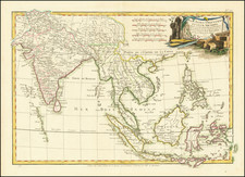
Detailed plan of Manila Bay and the Port of Acapulco, from George Anson's A voyage round the world in the years MDCCXL, I, II, III, IV by George Anson, Esq., commander in chief of a squadron of His Majesty's ships sent upon an expedition to the South-seas.
The maps show two of the principal harbors of the Manila Galleon Trade, along with a profile view of the Ladrone Islands. The harbor plan for Manila locates anchorages, souundings in the primary entrance and some topoographical details.
The map shows the Puente Grande in Manila, the first bridge built in the area. Built between 1626 and its opening in 1630, connecting the districts of Binondo to the capital. Regarding the importance of the Bridge and its connection to Binondo, British politician and economist Sir John Bowring wrote:
Binondo is really the most important and most opulent pueblo in the Philippines, and is the real commercial capital: two-thirds of the houses are substantially built of stone, brick and tiles, and about one-third are Indian wooden houses covered with the nipa palm. The place is full of business and activity. An average was lately taken of the carriages daily passing the principal thoroughfares. Over the Puente Grande (great bridge) their number was 1,256; through the largest square, Plaza de San Gabriel, 979; and through the main street, 915. On the Calzada, which is the great promenade of the capital, 499 carriages were counted. These accounted for the aristocracy of Manila.
Admiral Anson chased a Spanish treasure galleon from Manilla to Acapulco, capturing it in a chance meeting. When he got his haul home 32 wagons were needed to transfer the silver from the port to the Tower of London.
![Mapa et tierra q[u]e yos pedro Vial taigo transitau en St. Tafee este dia 18 de Octubre de La ao 1787](https://storage.googleapis.com/raremaps/img/small/3645.jpg)
![[Philippines] Typus Freti Manilensis. Die Straet vande Manilles](https://storage.googleapis.com/raremaps/img/small/85438.jpg)
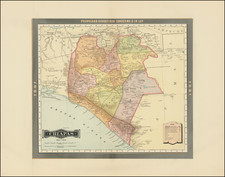
![(Texas Mexico Borderlands) [Map of the Rio Grande, Texas - Mexico border, from the Big Bend to the town of Mier] Copiado del Mapa de S. Mc. L. Staples, 1828... Dibujado y extractado de los documentos y datos dichos, por F. L. Mier - Monterey, Diciembre de 1873.](https://storage.googleapis.com/raremaps/img/small/91667.jpg)
![(Mexican-Aztec Artwork) [Original pencil tracing of Aztec Calendar]](https://storage.googleapis.com/raremaps/img/small/102327.jpg)