
This item has been sold, but you can enter your email address to be notified if another example becomes available.


|
||

|

|
|

|
Stock# 8648
Description
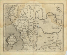
Latin edition of Claesz's map of America, which is largely based upon the 1587 edition of Abraham Ortelius' map of America. Includes Anian, Quivira, Totoeac, Tolm R., Granada, Norombega, Marata, Virginia, Florida, Corterealis, and Nova Francia, with a reference to Columbus' Discovery of America in 1492. Unknown southern continent show, along with the Fretum Magellicum, by no sign of the Le Maire Straits. Decorative Strapwork in the corners. This example appeared in Petrus Bertius' Tabularum Geographicum. Burden 92.

![[Portrait] L'Amerique.](https://storage.googleapis.com/raremaps/img/small/79745.jpg)