|
||

|

|
|

|
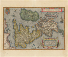
Decorative map of the British Isles, published by Covens and Mortier in Amsterdam, after the second state of Carel Allard's final map of the region.
The map is a stunning and highly detailed depiction of the geography and culture of Great Britain in the late 17th century. Its intricate details and beautiful design make it a valuable historical artifact and a fascinating piece of cartographic art.
One of the most prominent features of the map is the large allegorical title cartouche, which features cherubs and a large coat of arms, framed by a lion and unicorn.
The map itself is divided into several regions, including England, Scotland, and Ireland. The coastlines are carefully delineated and include many small towns and cities, as well as some larger port cities such as London and Edinburgh.
At the top left is a large inset map of the Orkney Islands, which are located off the northern coast of Scotland. The inset map is highly detailed and includes many small islands, bays, and peninsulas.
Johannes Covens (1697-1774) was a Dutch geographic publisher based in Amsterdam. He is best known for his collaboration with fellow publisher Cornelis Mortier (1699-1783). Pierre Mortier the Elder (1661-1711) had obtained a privilege in 1690 to distribute the works of French geographers in the Netherlands. After his widow continued the business for several years, Cornelis took over in 1719.
In 1721, Mortier forged a partnership with Covens, who had recently married Cornelis’ sister. They published under the joint name of Covens & Mortier. In 1774, upon the death of his father, Johannes Covens II (1722-1794) took over his father’s share. In 1778, the company changed its name to J. Covens & Zoon, or J. Covens & son.
Covens II’s son, Cornelis (1764-1825), later inherited the business and brought Petrus Mortier IV back into the fold. Petrus was the great-grandson of Petrus Mortier I. From 1794, the business was called Mortier, Covens & Zoon, or Mortier, Covens, & Son.
The business specialized in publishing French geographers including Deslisle, Jaillot, and Sanson. They also published atlases, for example a 1725 reissue of Frederik de Wit’s Atlas Major and an atlas, with additions, from the works of Guillaume Delisle. There were also Covens & Mortier pocket atlases and town atlases. The company profited from acquiring plates from other geographers as well. For example, the purchased Pieter van der Aa’s plates in 1730. Finally, they also compiled a few maps in house. At their height, they had the largest collection of geographic prints ever assembled in Amsterdam.
Cornelis Mortier (1699-1783) was a Dutch publisher who specialized in geography. Cornelis’ father, Pierre Mortier the Elder (1661-1711), had obtained a privilege in 1690 to distribute the works of French geographers in the Netherlands. After his widow continued the business for several years, Cornelis took over in 1719.
In 1721, Mortier forged a partnership with Johannes Covens, who had recently married Cornelis’ sister. They published under the joint name of Covens & Mortier. Their firm was one of the largest and most successful in Dutch history and continued in business until the late-nineteenth century.
In 1774, upon the death of his father, Johannes Covens II (1722-1794) took over his father’s share. In 1778, the company changed its name to J. Covens & Zoon, or J. Covens & Son. Covens II’s son, Cornelis (1764-1825), later inherited the business and brought Petrus Mortier IV back into the fold. Petrus was the great-grandson of Petrus Mortier I. From 1794, the business was called Mortier, Covens & Zoon, or Mortier, Covens, & Son.
The business specialized in publishing French geographers including Deslisle, Jaillot, and Sanson. They also published atlases, for example a 1725 reissue of Frederik de Wit’s Atlas Major and an atlas, with additions, from the works of Guillaume Delisle. There were also Covens & Mortier pocket atlases and town atlases. The company profited from acquiring plates from other geographers as well. For example, the purchased Pieter van der Aa’s plates in 1730. Finally, they also compiled a few maps in house. At their height, they had the largest collection of geographic prints ever assembled in Amsterdam.
![[England, Scotland & Wales]. Parte Settentrionale del Regno d'Inghilterra . . . (with) Parte Meridionale del Regno d'Inghilterra . . .](https://storage.googleapis.com/raremaps/img/small/89516.jpg)