|
||

|

|
|

|
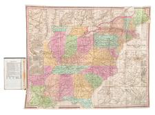
Marvelous map of the United States & Canada, colored by states and showing towns, railroads, mountains, rivers, Indian Tribes, forts, etc. One of the most interesting features is the odd configuration of Wyoming, which is named only Attached to Dacota. Many early interesting features in the Transmississippi West. Clean fold split enters two inches into the image. An excellent Civil War vintage map of the region. Still a very attractive map.
Samuel Augustus Mitchell Jr. inherited the Mitchell Company from his father in 1860. For over thirty years, the company had specialized in the production of school atlases and wall maps of America. They were one of the pioneers on engraving on steel plates. In 1860, Samuel Jr. released the New General Atlas, which had been compiled in house and replaced a previous atlas by Tanner. The elder Mitchell died in 1868 and Samuel Jr. continued the business until the 1890s. At its height, the Mitchell Company employed 250 people and sold 400,000 publications annually.