|
||

|

|
|

|
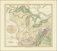
Cornell's Outline Maps No. 6, produced in 1859 by G. Woolworth Colton for D. Appleton & Co. to accompany Cornell's Series of School Geographies, provides an instructive and detailed view of the middle portions of th United States.
Centered on the Mississippi River and Ohio River and Missouri Rivers, the map helps students identify the location of states, rivers and major cities, all unnamed.
A fascinating learning tool, ts association with Cornell's Series of School Geographies underscores its role as a conduit for disseminating geographic knowledge to a growing population of learners.
G. W. & C. B. Colton was a prominent family firm of mapmakers who were leaders in the American map trade in the nineteenth century. The business was founded by Joseph Hutchins Colton (1800-1893). who bought copyrights to existing maps and oversaw their production. By the 1850s, their output had expanded to include original maps, guidebooks, atlases, and railroad maps. Joseph was succeeded by his sons, George Woolworth (1827-1901) and Charles B. Colton (1831-1916). The firm was renamed G. W. & C. B. Colton as a result. George is thought responsible for their best-known work, the General Atlas, originally published under that title in 1857. In 1898, the brothers merged their business and the firm became Colton, Ohman, & Co., which operated until 1901, when August R. Ohman took on the business alone and dropped the Colton name.