|
||

|

|
|

|
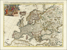
Cornell's Outline Maps No. 11, drawn by G. Woolworth Colton to accompany Cornell's Series of School Geographies and published by D. Appleton & Co in New York in 1859, is a didactic wall map of Europe. Characterized by its lack of labels, it displays divisions and major cities marked with circles and stars, serving as an educational tool designed to encourage geographical learning and memorization.
The mid-19th century was a time of educational reform and expansion in many parts of the Western world, and the emphasis on geography was part of a broader movement towards comprehensive education. The production of didactic maps like this one was aimed at enhancing spatial awareness and understanding of the geopolitical structure of the continent. In this context, the decision to exclude labels was likely a deliberate pedagogical strategy, challenging students to identify locations based on shape, division, and symbol alone.
The work of G. Woolworth Colton, a prominent figure in American cartography, adds further significance to this map. Colton's skill in conveying geographical information in a clear and aesthetically pleasing manner is evident in the clean lines and careful rendering of the continent's divisions. The use of symbols, such as circles and stars for major cities, introduces a level of abstraction that aligns with the map's educational intent, simplifying complex information into an accessible format.
Cornell's Outline Maps No. 11 stands as both a historical document and a pedagogical artifact, reflecting the educational methodologies and cartographic practices of its time. Its unique design, devoid of labels yet rich in spatial information, exemplifies an innovative approach to geographical education. By presenting Europe in a manner that demands active engagement and critical thinking, this map encapsulates the spirit of educational inquiry that characterized the mid-19th-century educational landscape. It represents a confluence of art, science, and education, a testament to the era's commitment to fostering intellectual growth and global awareness.
G. W. & C. B. Colton was a prominent family firm of mapmakers who were leaders in the American map trade in the nineteenth century. The business was founded by Joseph Hutchins Colton (1800-1893). who bought copyrights to existing maps and oversaw their production. By the 1850s, their output had expanded to include original maps, guidebooks, atlases, and railroad maps. Joseph was succeeded by his sons, George Woolworth (1827-1901) and Charles B. Colton (1831-1916). The firm was renamed G. W. & C. B. Colton as a result. George is thought responsible for their best-known work, the General Atlas, originally published under that title in 1857. In 1898, the brothers merged their business and the firm became Colton, Ohman, & Co., which operated until 1901, when August R. Ohman took on the business alone and dropped the Colton name.
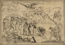
![(Prussian Octopus) En 1788 Mirabeau disait deja: La Guerre est l’industrie Nationale de la Prusse [Already in 1788 Mirabeau was saying: War is the national industry of Prussia]](https://storage.googleapis.com/raremaps/img/small/76554.jpg)