


|
||

|

|
|

|
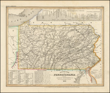
Cornell's Outline Maps No. 4, produced in 1859 by G. Woolworth Colton for D. Appleton & Co. to accompany Cornell's Series of School Geographies, provides an instructive and detailed view of the northeastern United States. Spanning from Delaware to Maine, the map covers an extensive area, including Pennsylvania, New Jersey, New York, Connecticut, Rhode Island, Massachusetts, Vermont, and New Hampshire. Additionally, it includes insets of two significant urban centers of the time—Boston and New York—contributing additional depth and detail to this educational resource.
The Northeast, as depicted in this map, was a hub of industrial, commercial, and cultural activity during the mid-19th century. The region was marked by burgeoning cities, rapidly expanding transportation networks, and growing populations. Thus, a map detailing this region would have been instrumental in educating students about the geographic dynamics of their rapidly evolving nation.
The insets of Boston and New York serve as valuable supplements, providing a more intimate look at two of the major urban centers in the country at the time. Both cities were experiencing substantial growth and transformation in this period, with the advent of new infrastructures, burgeoning populations, and expanding commercial activities. The urban mappings offer a microcosmic view of these developments.
As a cartographic artifact, Cornell's Outline Maps No. 4 stands as a testament to the era's educational priorities and methodologies. It's more than a geographical tool; it's a historical document reflecting the socio-economic landscape of the northeastern United States during a time of significant change and expansion. Its association with Cornell's Series of School Geographies underscores its role as a conduit for disseminating geographic knowledge to a growing population of learners. This map is a compelling example of G. Woolworth Colton's commitment to precise, informative cartography, as well as a valuable artifact of the educational practices of the mid-19th century.
G. W. & C. B. Colton was a prominent family firm of mapmakers who were leaders in the American map trade in the nineteenth century. The business was founded by Joseph Hutchins Colton (1800-1893). who bought copyrights to existing maps and oversaw their production. By the 1850s, their output had expanded to include original maps, guidebooks, atlases, and railroad maps. Joseph was succeeded by his sons, George Woolworth (1827-1901) and Charles B. Colton (1831-1916). The firm was renamed G. W. & C. B. Colton as a result. George is thought responsible for their best-known work, the General Atlas, originally published under that title in 1857. In 1898, the brothers merged their business and the firm became Colton, Ohman, & Co., which operated until 1901, when August R. Ohman took on the business alone and dropped the Colton name.

![[ Temperance Allegorical View ] Black Valley Railroad. Tickets Sold at all Liquor Shops. Accidents by Collisions are Entirely Avoided, as no up Trains are Run Over the Road.](https://storage.googleapis.com/raremaps/img/small/101469.jpg)