|
||

|

|
|

|
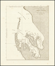
This Italian map, titled "Carta dell'ultimo Viaggio del Capitano Kook 1785," details the geographic expanse covered during Captain James Cook's final voyage. The map outlines portions of the North Pacific Ocean, including the frigid Arctic circle with sparse northern landmasses, parts of Asia, and the west coast of North America, down to the more defined outlines of islands in the South Pacific.
Distinctive features include the Mar Pacifico (Pacific Ocean), along with key locations such as the Siberian coast and Kamchatka Peninsula. The detailed coastline of California is visible, noted before the advent of more advanced cartographic precision. Intriguingly, parts of the map reflect the limited European knowledge of the Pacific Northwest at the time.
Islands in the South Pacific, such as Nuova Zelanda (New Zealand) and the islands Cook visited in Polynesia, are also depicted, though with varying degrees of accuracy compared to modern maps. The term "Nuova Caledonia" refers to New Caledonia, and "Nuove Isole Australe" likely denotes the group of islands in the southern Pacific that were encountered during Cook's voyages.
This 1785 map serves as a historical document, encapsulating the extent of European geographical knowledge following Cook's explorations. It reflects the contributions of Captain Cook to the Age of Discovery, especially in charting the Pacific, and showcases the period's European perspective on world geography.
![Asia [with Australia]](https://storage.googleapis.com/raremaps/img/small/72516.jpg)