|
||

|

|
|

|
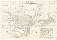
Singapore At The Time of Approval of its "Master Plan"
Fine large bilingual map of Singapore, published by the Singapore Improvement Trust (Planning Department).
This is an exceptionally detailed map of Singapore, extending outward to Bukit Timah, Saranggong, Ulu Kalang and Ang Mo Kio. The plan illustrates the Malayan Railway Line, waterfront, major roads, streets, estates, parks, schools and colleges, government buildings, factories, clubs, the Football Stadium Ground, temples, cemeteries, and other points of interest.
The map also shows the location of the Malay Settlement. In the 1950s and 1960s, the northern coast of Singapore was populated by the Malay community, and the area became known as the Malay Settlement, or Petempatan Melayu Sembawang.
The present map is related to Singapore's "Master Plan," which was intended to create an orderly approach to the growth and development of the modern city. This was the first master plan of Singapore since Raffles’s Town Plan was initiated in 1822. From 1952 to 1955, the SIT worked on the Master Plan. A diagnostic survey of Singapore was conducted from 1952 to 1953 and involved studies on the land and building use of the central (city core), urban and rural areas, as well as traffic flow and the industries that would provide employment for the people. The master plan aimed to provide a blueprint to guide the physical development of Singapore so there would be adequate land for residents to live, work, and play in a conducive environment.
The SIT Master Plan was submitted to the Singapore government for approval in 1955. The Master Plan made significant re-zoning and transport infrastructure recommendations, including an improved road network and the creation of new urban centers which would function separately from the main city. The draft of the master plan was completed in 1955 and then exhibited for a period of six weeks in 1956 to obtain public feedback. The final report of the master plan was approved by the government on August 8 1958.
Singapore Improvement Trust
The Singapore Improvement Trust (SIT) was a government organization that oversaw the urban planning and urban renewal process in Singapore from 1927 to 1969. Created under the Singapore Improvement Ordinance in 1927, the SIT was based upon a model created by larger cities in India.
In its early years, the SIT focused on back lane improvement projects and the demolition of unsafe buildings. From 1935, it increasingly focused on the creation of public housing projects. After World War II, the SIT focused its attention on the repair of these residential developments before constructing additional public housing beginning in 1947.
The SIT was also involved in the creation of Singapore's "Master Plan" from 1952 to 1958
In the late 1950s, the process of replacing SIT began with the creation of separate organizations, the Housing and Development Authority, and the Planning Authority. SIT formally dissolved in 1960.