|
||

|

|
|

|
Stock# 85446
Description
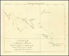
Rare early 19th Century example of James Burney's map the area between the Philippines, Palau and the Caroline Islands.
The map focuses on the discoveries of the Spanish in the 16th and 17th Centuries and the English in teh 18th Century.
James Burney (1750-1821) was a rear admiral, who began his career on the last 2 of Cook's voyages of Circumnavigation. The map appeared in his Chronological History of the Voyages and Discoveries in the South Sea or Pacific Ocean (London, 1803–1817).