|
||

|

|
|

|
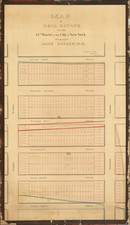
Scarce Pocket Map Edition
Detailed map of New York City and vicinity, oriented with North at the top, published by GW & CB Colton.
The map is unusual for the period, as most double page atlas maps of New York City from this era are oriented with East at the top.
Shows parks, streets, wards, buildings, rail lines, wharfs, and many other features. Inset of Upper NYC and part of Westchester County. Also shows much of Brooklyn, Hoboken and Jersey City.
G. W. & C. B. Colton was a prominent family firm of mapmakers who were leaders in the American map trade in the nineteenth century. The business was founded by Joseph Hutchins Colton (1800-1893) who bought copyrights to existing maps and oversaw their production. By the 1850s, their output had expanded to include original maps, guidebooks, atlases, and railroad maps. Joseph was succeeded by his sons, George Woolworth (1827-1901) and Charles B. Colton (1831-1916). The firm was renamed G. W. & C. B. Colton as a result. George is thought responsible for their best-known work, the General Atlas, originally published under that title in 1857. In 1898, the brothers merged their business and the firm became Colton, Ohman, & Co., which operated until 1901, when August R. Ohman took on the business alone and dropped the Colton name.
![[Brooklyn] A Map of ten Lots of land bounded on high water mark as the same was deemed to be on the 20th day of May 1761 on the East River now Brooklyn Ferry in Kings County._ Resurveyed according to the original Map thereof on the first day of May 1813. . .](https://storage.googleapis.com/raremaps/img/small/47354.jpg)
![[Brooklyn] The Anderson T. Herd Realty Co's Map of the Borough of Brooklyn & Part of Queens with Present & Projected Transit Lines, Elevated & Surface Railways, Bridges, Tunnels & Subways . . . 1906](https://storage.googleapis.com/raremaps/img/small/84230.jpg)
![[ New York City View ] Buckley's New York Quadrille](https://storage.googleapis.com/raremaps/img/small/86578.jpg)