|
||

|

|
|

|
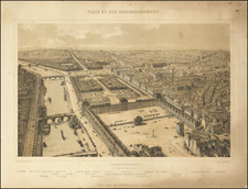
Paris on the Eve of Haussmann
Scarce map of Paris, published shortly before Louis-Napoleon Bonaparte was elected President of France in December 1848.
At the beginning of Napoleon's reign, Paris had a population of about one million people, most of whom lived in crowded and unhealthy conditions. A cholera epidemic in the overcrowded center in 1848 killed twenty thousand people. In 1853, Napoleon launched a gigantic public works program under the direction of his new Prefect of the Seine, Georges-Eugène Haussmann, whose purpose was to put unemployed Parisians to work and bring clean water, light and open space to the center of the city. This period, often referred to as "Haussmann's renovation of Paris," saw the transformation of the city from a medieval city with narrow, winding streets to a modern metropolis with broad boulevards, parks, and public squares.
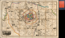
The present map illustrates Paris on the eve of the Cholera outbreak which would catalyze the redesign of the City over the next several decades. Fatout offers a stunning cartographic representation of Paris,. As its title suggests, this map illustrates the extensive network of fortifications and detached forts around the city, which played a crucial role in the city's defense during that period.
The walls of the city, as depicted on the map, present a formidable barricade against potential invaders. Meticulously illustrated, the walls highlight not only the fortification walls but also the various gates leading into the city. Paris, at this time, was encased within Thiers' wall, named after the Prime Minister Adolphe Thiers who commissioned it in 1841 as a defense mechanism. These encompassing walls were dotted with 94 bastions, interspersed with larger forts at strategic points, all rendered meticulously in this map.
The fortifications immediately outside the city are strategically positioned and detailed. These include a complex array of detached forts designed to supplement the city's defenses. These forts were positioned to offer a wider defensive perimeter and deter any would-be attackers.
The vignette of the two rail lines entering the city from the south, from Versailles and Sceaux, and the two from the north, from Belgique and S. Germaine, is a unique depiction of the burgeoning railway system. The railways, represented by fine lines with stops marked along their lengths, lead to intricate representations of the station buildings at their termini.
However, the most extraordinary feature of this map is its artistic incorporation of illustrated vignettes of over 25 bridges and around 50 major buildings and monuments. The bridges, each named and carefully illustrated, span the Seine, depicted with delicate ripple effects that provide a striking contrast to the dense urban landscape.
Among the buildings and monuments featured are many of Paris's most iconic landmarks, including Notre-Dame, the Louvre, and the Palais Royal. Each building is represented in delicate detail, offering a glimpse of Parisian architectural grandeur. These illustrations are not merely decorative; they help orient the viewer and underscore the city's rich cultural and historical heritage.
Overall, this 1847 map is a masterful blend of practical cartography and artistic representation, reflecting Paris's status as a fortified city and a burgeoning cultural and transportation hub. It serves as an intricate historical document and a testament to the city's evolving landscape during the mid-19th century.