|
||

|

|
|

|
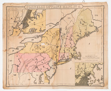
An Historical Map of Pennsylvania is a fascinating historical document published in 1875 by P. W. Sheafer and others. This publication was funded by the Historical Society of Pennsylvania and features a comprehensive treatment of Pennsylvania's past, including the Native American names of streams and villages, paths of travel, old fort sites and battlegrounds, and the gradual acquisitions of territory through treaties with the indigenous tribes.
The map provides detailed information about the progression of land acquisitions in Pennsylvania from the Native Americans under various treaties:
- The first treaty was signed with the Delawares on September 17, 1718, and confirmed by the Five Nations on October 25, 1736.
- The second treaty was established with the Five Nations in Philadelphia on October 11, 1736.
- The third treaty was with the Six Nations, also in Philadelphia, on August 22, 1749, for £500.
- The fourth treaty took place with the Six Nations at Easton on October 23, 1758.
- The fifth treaty was with the Six Nations at Fort Stanwix on November 5, 1768.
- The sixth treaty also took place at Fort Stanwix with the Six Nations on October 23, 1784.
- Finally, a Deed of Confirmation for 202,187 acres from the United States was secured for $151,640 on March 3, 1792.
The lithograph of the map was done by Lehman & Bolton, located at 418, 420 & 422 Library St., Philadelphia.
Intrestingly, the map includes an image supposed to be an Indian map, found on a large gray sandstone block. This block, measuring three-and-a-half feet long, two feet wide, and one foot thick, was discovered on the Susquehanna River near Sinnemahoning by Walter R. Johnson in 1836. This primitive map, with its double waving line (A. B.) believed to represent the Susquehanna River and animal figures (D. E.) likely symbolizing deer and elk, serves as a unique glimpse into the Native American understanding of the land.
![1794 Land Survey Signed by Alexander McDowell D[eputy] S[urveyor]](https://storage.googleapis.com/raremaps/img/small/101014.jpg)
![(Early Philadelphia Architectural Drawings) Plan of the ceiling of St. Andrews Church [with two additional drawings on another sheet]](https://storage.googleapis.com/raremaps/img/small/90443.jpg)