|
||

|

|
|

|
Stock# 84977
Description
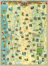
Fine vintage topographic map of the Modoc area in the far northeastern corner of California.
The map stretches eastwards the year-round and seasonal lakes near the Oregon-Nevada-California border. Westwards, the map extends into Shasta-Trinity national forest and Siskiyou and Shasta Counties. Lava Beds National Monument, just south of Tule Lake National Wildlife Refuge, was established as a national monument in 1925.
This map was published by the USGS in 1962 based on earlier topographic maps and photogrammetric data from the late 1940s and early 1950s.
![[Avalon / Catalina] Island Villa Villa Park and Las Casitas House Keeping Bungalows](https://storage.googleapis.com/raremaps/img/small/73382.jpg)
![[Drake's Bay to Fort Bragg] Bodega Head to Abalone Point From The Latest United States Government Charts . . .](https://storage.googleapis.com/raremaps/img/small/73078.jpg)