|
||

|

|
|

|
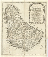
Finely executed Spanish sea chart of Antigua published in Madrid by Tomas Lopez .
As noted in the top right corner, the map is drawn from English charts, most notably the work of Robert Baker, Surveyor General for Antigua, with later improvements by Lacques Nicolas Bellin in 1758.
Lopez's chart divides the island into five parishes: San Juan, Parham, San Pedro, Willoughby, and Falmouth. The chart identifies smaller satellite islands, towns and cities (including the capital, St. John's), mountains, rivers, bays, roads, a fishing hole, and churches. The Lucas and Codrington plantations are marked with windmills. Navigational information such as soundings, banks, anchorages, and hazards are shown.
Rarity
As with most Spanish maps of the period drawn by one of Spain's great englightenment cartographic publishing houses, the chart is rare on the market.
![[Hispaniola, Cuba, Martinique and Guadalupe] Carte de S.Domingue . . . / Carte de Cuba . . . / Carte de Martinique . . . / Carte de Guadalupe et des Isles de Saintes . .](https://storage.googleapis.com/raremaps/img/small/70543.jpg)
![[ Virgin Islands, etc ] Supplément pour les Isles Antilles, extrait des cartes Angloises](https://storage.googleapis.com/raremaps/img/small/98774.jpg)
![[Heighted with Gold] Pascaert Vande Caribes Eylanden](https://storage.googleapis.com/raremaps/img/small/91150.jpg)