|
||

|

|
|

|
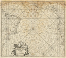
Learning to Chart and Daring to Correct
Striking early eighteenth-century manuscript chart of Fernando de Noronha, in the western Atlantic.
This is a close copy of a Thames School chart of the archipelago from ca. 1680. The handwriting dates it to the early-eighteenth century, at least a generation after the original was made.
The charts are very similar, although the eighteenth-century copyist has moved the compass rose and altered the steps of the scale slightly. A significant note, in a late-eighteenth century hand, says, “This draft is extremely erroneous.”
While at first funny, the comment also points to the changing expectations of charts in the early modern period. It was likely made by a student of the sea a generation after the original was drawn. The stylistic profile view was favored by seventeenth-century navigators, as it showed a coast as if seen from a ship.
By the time the note was added to this chart, preferences had clearly changed. Charts were by then typically drawn in plan and did not include the topographic details seen here. They also tended to show larger areas than a single coastline, as Thames School charts were drawn as a combination of sailing directions and charts.
This is therefore a fascinating palimpsest—an admiring copy of the product of a respected school of chartmakers that, by a century later, was no longer appreciated due to the changing conventions of navigation and hydrography.
Fernando de Noronha
Fernando de Noronha was sighted early in the encounter between Europeans and the Americas. By 1500, Spanish charts already showed it. It is included in the Cantino Planisphere (1502) as Quaresma, although that designation is still contested by scholars.
The earliest known landing at the islands was on August 10, 1503, when a group of Lisbon merchants, led by Fernão de Loronha, financed an expedition to explore it more closely. Led by Captain Gonçalo Coelho, the crews included Amerigo Vespucci, who wrote of the trip. The flagship hit a reef near the main island and foundered. Vespucci made it to a safe anchorage and called the island St. Lawrence, as it was the feast day of that saint.
In 1504, King Manuel I of Portugal granted the island to Loronha as a charter. It was now called St. John’s Island, renamed by another Portuguese visitor in search of Vespucci. Over time, however, the archipelago came to be called after Loronha and his family, who maintained their ownership until the 1560s. Noronha is a common misspelling of Loronha.
Later in the sixteenth century, Fernando de Noronha became the central collection point for brazilwood, a trade in which Loronha was heavily involved. Later, in 1719, the pirate Bartholomew Roberts (Black Bart) spent time on the island and points to continued English interest in the island that is reflected in this chart.
The Thames School
The island was charted by Captain Henry Foster of HMS Chanticleer on a surveying expedition in 1828. However, it was also charted in various levels of detail long before by the Spanish, Portuguese, and, as this chart shows, the English. The style of the chart from which this example is copied dates it to ca. 1670-80, when English privateers and buccaneers were roving the western Atlantic in search of ships and trade, both legal and illicit. This copy was made ca. 1710.
The late-seventeenth century was the heyday of the Thames School of chartmakers, who in turn patterned their work on the Mallorcan style of late portolan charts. The demand for English nautical charts increased sharply from the mid-sixteenth century. Chartmakers gravitated to Thames-side enclaves like Wapping, Ratcliff, the Minories, Limehouse, and Stepney to fill this demand.
While many engraved charts were available (and some members of the Thames School produced printed charts), the Thames School specialized in hand-drawn charts, often on vellum. Thomas R. Smith has traced at least seven generations of masters and apprentices who formed the school of artisan practitioners along the banks of the Thames, hence their name. Many of these were part of the Drapers Company, underlining that map and chartmakers were part of many companies and not necessarily attached to the Stationers as is commonly assumed. Members included John Burston, Nicholas Comberford, John Thornton, Joel Gascoyne, John Daniell, Nicholas Reynolds, Thomas Lupo, Thomas Hood, Gabrieell Tatton, and John (father) and Robert (son) Friend.
The most famous, and one of the last, members of the Thames School was William Hacke. Hacke made over 300 charts, including lavish presentation atlases based on a Spanish deroterro captured by the pirate Bartholomew Sharpe. Several examples of these atlases survive, preserving the humped hills, spiked writing, careful line work, refined use of gold and color, and elaborate compass roses that were characteristic of the Thames School style. While the original of this chart does not appear to be by Hacke (based on a comparison of the handwriting and the details of the compass rose), it was completed by a member of the School and fits within their important oeuvre, hence why someone would bother to draw their own version of it decades later.
![[Whaling Operations] Pesca della Balena | Pesca del Pesce Sega](https://storage.googleapis.com/raremaps/img/small/78472.jpg)