|
||

|

|
|

|
Stock# 84864
Description
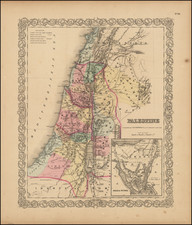
Original antique map of Palestine, published by Christoph Wiegel in Amsterdam. The map shows the Holy Land in detail, with pictorially depicted topography and many important Biblical and modern cities and towns shown.
The map is divided into the regions of Samaria, Galilee, and Judea. The map includes a strange decorative cartouche of a reclining man in the ruins of a classical edifice, typical of this period of mapmaking. This map was originally published in Weigel's work on Geographia Antiqua, edited by D. Kohler.
Condition Description
Original hand-color. Manuscript underlining.
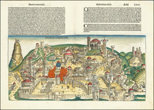
![(Nuremberg Chronicle) [Saul and Odysseus]](https://storage.googleapis.com/raremaps/img/small/98684.jpg)
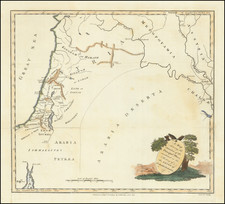
![(Czech Edition) Tabule zemj, fragin a mest/w nichz G. Paivael fazal [Bunting's Map of the Eastern Mediterranean Region]](https://storage.googleapis.com/raremaps/img/small/93467.jpg)