This item has been sold, but you can enter your email address to be notified if another example becomes available.


|
||

|

|
|

|
Stock# 84855
Description
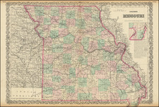
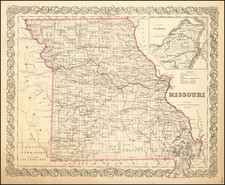
Highly detailed map of Missouri, published by O.W. Gray.
The map is colored by counties and shows towns, roads, railroads, post offices, etc.
Inset map of the southeastern bootheel of Missouri.
Condition Description
Original hand-color by county. Minor foxing, mostly contained to top margin.
O.W. Gray Biography
O. W. Gray was a publishing firm based in Philadelphia. Later, they published as O. W. Gray & Son. They published atlases in the late nineteenth century. Gray's National Atlas was one of the most successful commercial ventures of the 1870s and one of the last to employ hand coloring on maps.
![[Missouri, Illinois, Indian Territory, Kansas, Nebraska, Iowa] Amer. Sep. No. 49. Partie des États Unis](https://storage.googleapis.com/raremaps/img/small/74904.jpg)