|
||

|

|
|

|
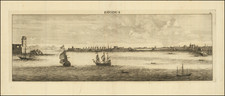
Finely colored and beautifully embellished example of JB Homann's plan of the Siege of Corfu,
Detailed and artistically rendered plan of the Seige of Corfu, offering an elaborate look at the Siege of 1716. The title translates to "Plan of the Siege of Corfu by Land and by Sea with the situation of the Venetian and Ottoman Fleets from the day the Ottomans entered the channel on the 5th of July until the 26th of August 1716, the day of its withdrawal." Coming in the aftermath of the Ottoman Empires' conquest of Morea in 1715, the siege was a major success for Venice, allowing it to preserve its rule over the Ionian Islands.
On the 8th of July 1716, the Ottoman fleet carrying 3,000 men sailed from Butrinto to Corfu. Simultaneously the Venetian fleet encountered the Ottoman fleet off the Channel of Corfu, defeating them in the ensuing naval battle.
The map itself is oriented with the east at the top, showing the naval forces of the Venetian Empire to the right (south in standard orientation) and the Ottoman naval force to the left (north in standard orientation). The decorative engraving of the map is superb, incorporated a sword-wielding lion of Venice and a magnificent tableau of an imperial figure, riding aboard a water-going chariot pulled by hippocampi, whilst in conversation with Neptune striding along beside.
The key on the left provides a general description of the siege, detailing the military engagements and the positioning of the fleets. The circular images in the corners likely represent the naval positions of the fleets at four different moments in time within the Canal de Corfu. The land forces are illustrated firing upon the ships, and the military positions on Corfu are carefully noted, showcasing the complexity of the siege both on land and at sea.
The Siege of Corfu in 1716 was part of the wider conflict known as the Seventh Ottoman–Venetian War, which was itself a theater within the larger struggle between the Ottoman Empire and the European powers. During this particular siege, the forces of the Ottoman Empire, led by the Grand Vizier Damat Ali Pasha, attempted to capture Corfu as a stepping stone to secure a stronger position in the Adriatic Sea against the Venetian Republic. The Venetian forces were commanded by Count Johann Matthias von der Schulenburg, who skillfully defended the island. The siege was a crucial moment, as a victory for the Ottomans could have opened the door to further encroachments into European territory.
The outcome of the siege was a decisive victory for the Venetians. Schulenburg's leadership and the resilience of the Venetian forces led to the successful defense of Corfu, inflicting heavy casualties on the Ottomans.
Johann Baptist Homann (1663-1724) was a mapmaker who founded the famous Homann Heirs publishing company. He lived his entire life in Bavaria, particularly in Nuremberg. Initially, Johann trained to become a priest before converting to Protestantism and working as a notary.
In 1702, Johann founded a publishing house that specialized in engravings. The firm flourished, becoming the leading map publisher in Germany and an important entity in the European map market. In 1715, Johann was named Imperial Geographer to the Holy Roman Empire by Charles VI and made a member of the Prussian Academy of Sciences. Most importantly for his business, his reputation and contacts gained him imperial printing privileges which protected his publications and recommended him to customers. Johann is best known for this Grosser Atlas ueber die ganze Welt, or the Grand Atlas of the World, published in 1716.
After Johann died in 1724, the business passed to his son, Christoph (1703-1730). Upon Christoph’s early death, the company passed to subsequent heirs, with the name of the company changing to Homann Erben, or Homann Heirs. The firm continued in business until 1848.
![[ Greece ]. Neuw Griechenlandt mit andern anstossenden Landern / wie es zu unsern zeiten beschribenist](https://storage.googleapis.com/raremaps/img/small/80551.jpg)