
This item has been sold, but you can enter your email address to be notified if another example becomes available.


|
||

|

|
|

|
Stock# 84708
Description
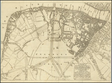
Fine original antique map of the districts of Holborn and Covent Garden in central London, produced by Richard Blome for Strype's 1720 annotated reissue of Stow's 16th-century Survey of the Cities of London and Westminster.
The map shows, in fantastic detail, this storied and central part of London. The region is named according to its parishes, which are the two adjoining parishes of St. Clements Danes and St. Mary Savoy. 61 places of interest are listed in an index.
The map shows the region bounded by Lincoln Inn Fields and the Thames River. The Strand, Fleet Street, and Prince Street are shown. Stairs up the Thames embankment are shown. Somerset House is shown in fine detail, as is the west part of the Temple.
Condition Description
Minor dampstain at top, entering image.

![[ London ] Die Gegend um London](https://storage.googleapis.com/raremaps/img/small/103695.jpg)