


|
||

|

|
|

|
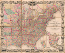
Striking full-color example of Barber & Willard's rare wall map of the United States, one of the most decorative coast to coast maps of the United States published prior to 1840.
The map is particularly noteworthy for its treatment of the Trans-Mississippi West, offering a relatively clean depiction of the river systems west of the Mississippi River, relatively free of the speculative information that often accumulates in thinly explored regions. The map gives a meticulous treatment of the Missouri River, with notes on Indian Villages and Indigenous populations and the occasional reference to Lewis & Clark. Further west, the map retains the single Cordillera of the Rocky Mountains popularized by Humboldt, but with no pretense of a prospective easy portage across the Rocky Mountains, an important improvement from the maps of Aaron Arrowsmith and his contemporaries, but with the Lewis & Clark Route across the Rocky Mountains plainly shown.
In Oregon Territory, the map identifies a remarkable number of Indian Tribes, including the Indigenous populations for well over a dozen tribes. The detail of the tributaries of the Columbia is relatively well developed, but further south, the lack of exploration is apparent, most notably the Rio Los Mongos, flowing from Lake Timpanogos, the semi-mythical depiction of the Great Salt Lake, demonstrates a profound lack of knowledge of the region which would persist until Fremont's explorations in the 1840s.
The map locates the "Provincia de Texas," suggesting a prospective Mexican source for the map. The cartographic treatment of the regions is quite restrained, with only a small number of settlements shown, primarily those on the major trade routes into New Mexico and Mexico.
In California, the river system is derived from early Spanish sources, in some cases very inaccurately so. Most notable is the mythical "Rio de Las Piramides sulferas", which parallels the course or the Colorado River ab out 100 miles to the west, through what in reality would be a very dry and inhospitable plain of eastern part of the Coachella Valley and Anza Borrego Desert. A number of Indian Tribes are located. The sizes shown for San Diego Bay and San Pedro Bay are far too large.
In the Midwest, the massive Northwest Territory includes a massive Michillimackinac County, extending from Green Bay to the Mississippi River. Crawford County and Brown County are shown in what would become Wisconsin Territory in 1836, one year after this map was published. In Michigan Territory, counties are now shown in the southern part of the Territory, although the spelling of the R[iver] Kellemazoo is quite unusual.
In Illinois and Missouri, several Trading houses are still shown, as are the Bounty Lands Indian Boundary and the remnants of Longs Route to the Mississippi River.
As noted by Rumsey, Barber & Willard's map is a marvelous amalgam of cartographic sources, but is perhaps most noteworthy for its striking image of the United States. Rumsey notes:
An unusual map in two sheets, showing the continent coast to coast. Tanner's influence from his North America map is evident in the west, and Long's map has influenced the plains, but Tanner's U.S. map is the primary source . . . . The Great Basin is filled with a table of distances and heights of mountains (which convention appears in several maps published in Hartford about this time by Thrall, Huntington, Olney's Geography, etc.). Wheat mentions the 1849 and 1850 editions of this map published by Reed and Barber, but this much earlier and different edition was unknown to him. . . . After the 1835 edition, no editions until the 1848 by Reed and Barber (see our 1849, 1850 and 1854 editions).
Rarity
The map is very rare on the market, this being the second example we have seen in about 30 years.
The last catalogued example of the map was the 1852 edition, offered by Richard Arkway Inc. in catalog 52, item #18.
![Texas [The Rand McNally Vest Pocket Map of Texas]](https://storage.googleapis.com/raremaps/img/small/86827.jpg)
![(Texas and California) The Whig Almanac and United States Register for 1843 [bound with:] The Whig Almanac and Politicians' Register for 1845 [bound with:] The Whig Almanac, and Politicians' Register for 1846 [with maps of Texas and Oregon] [bound with:] The Whig Almanac: 1847.](https://storage.googleapis.com/raremaps/img/small/87041.jpg)