This item has been sold, but you can enter your email address to be notified if another example becomes available.


|
||

|

|
|

|
Stock# 84546
Description
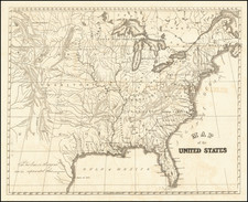
Scarce reduction of Aaron Arrowsmith's wall map of the United States, one of the most accurate maps of the nascent country published at the end of the 18th and the start of the 19th centuries. This reduction was published by Cadell and Davies in London.
The map extends inland past the Mississippi River, showing Indian settlements in the Midwest. Rivers and cities are shown throughout. Michigan retains its early configuration.
![[United States]](https://storage.googleapis.com/raremaps/img/small/93852.jpg)
![Vereinigte Staaten Von Nordamerika [United States of North America]](https://storage.googleapis.com/raremaps/img/small/92015.jpg)
![(Coast of Florida, Georgia and the Carolinas] [To The Members Of The Nautical Institution And Ship-Masters' Society Of The City Of New York, This Chart, Extending From Lat. 40°15 N., Long. 72°15 W., to Lat. 22°35 N., Long. 80°25 W., Is Respectfully Dedicated / By Their Obedient Servant Edmund M. Blunt]](https://storage.googleapis.com/raremaps/img/small/77294.jpg)