This item has been sold, but you can enter your email address to be notified if another example becomes available.


|
||

|

|
|

|
Stock# 84180
Description
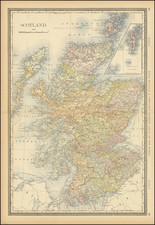
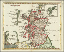
Wilkinson's map of Scotland.
The map is hand colored by counties and showing towns, rivers, lakes, islands, et cetera.
Robert Wilkinson was active in London as a cartographic publisher from 1785 to 1825. He produced a number of nice works, including a General Atlas and a re-issuance of Bowen & Kitchen's English Atlas, along with excellent large format separate maps.
Condition Description
Laid on Linen.
![[ Scotland -- Rare Siena Imprint ] Parte Settentrionale della Scozia . . . 1795 [and] Parte Meridionale della Scozia . . . 1795](https://storage.googleapis.com/raremaps/img/small/102864.jpg)