|
||

|

|
|

|
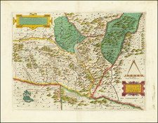
Melchior Tavernier's nicely engraved map of the post roads of France at the beginning of the 17th century.
According to a Princeton University site on thematic maps :
This is the first postal road map -also the first important map issued by Sanson. The map shows all of the routes used by the royal posts of the time, identifying the stops along the way; it was reprinted many times during the seventeenth century. Curiously, the cartouche for the dedication has been left blank. The French postal system dates back to 1477, when King Louis XI set up a Royal Postal Service that employed mounted couriers. The timing of this map is relevant, for private mail delivery had just been legalized several years earlier (1627), so both services were operating over the same major routes. In 1672, France made postal service a government-only function.
The post roads are shown here for the first time. Over the next 3 decades, this same map would be updated as routes were added.
The French Post
In 1477, Louis XI set up a Royal Postal Service, employing 230 mounted couriers, which was not intended for public use. The security and regularity of the service along certain routes, when compared to previous means of communication, inevitably resulted in an increasing amount of unofficial correspondence being carried. After initial attempts to prevent this practice, its fiscal advantages were realized, and private mailings were legalized in the early 17th Century. The basis of a real public service was not created until 1627, when fees and timetables were fixed and post offices established in the larger cities.
In 1672, France made postal services a controlled state monopoly. Previously granted private operators were allowed to continue, but over time they were forced out of business or acquired by the state. In 1719 the University of Paris, the most important private competitor, gave up its last postal privileges in return for substantial compensation.
Melchior Tavernier was a member of a large family involved in the publishing trade in Paris in the early years of the seventeenth century. Early in his career, he apparently collaborated with Henricus Hondius, as at least one of his early maps references Tavernier as the seller of a map engraved in Amsterdam, by Hondius. He is probably best known for his publication of a map of the Post Roads of France, which was copied many times until the end of the century. He also issued an atlas under the same title as J. le Clerc's Theatre Geographique, using many of Le Clerc's maps, but incorporating others from different sources. He published composite atlases and also published works for other cartographers, including N. Sanson, N. Tassin, and P. Bertius. He is not to be confused with his nephew of the same name (1594-1665), who also engraved maps for Nicolas Sanson.
Nicholas Sanson (1600-1667) is considered the father of French cartography in its golden age from the mid-seventeenth century to the mid-eighteenth. Over the course of his career he produced over 300 maps; they are known for their clean style and extensive research. Sanson was largely responsible for beginning the shift of cartographic production and excellence from Amsterdam to Paris in the later-seventeenth century.
Sanson was born in Abbeville in Picardy. He made his first map at age twenty, a wall map of ancient Gaul. Upon moving to Paris, he gained the attention of Cardinal Richelieu, who made an introduction of Sanson to King Louis XIII. This led to Sanson's tutoring of the king and the granting of the title ingenieur-geographe du roi.
His success can be chalked up to his geographic and research skills, but also to his partnership with Pierre Mariette. Early in his career, Sanson worked primarily with the publisher Melchior Tavernier. Mariette purchased Tavernier’s business in 1644. Sanson worked with Mariette until 1657, when the latter died. Mariette’s son, also Pierre, helped to publish the Cartes générales de toutes les parties du monde (1658), Sanson' atlas and the first French world atlas.

![(Bavaria) Palatinatus Bavariae Descriptio . . . [with] (Strasbourg) Argentoratensis Agri Descriptio](https://storage.googleapis.com/raremaps/img/small/82968.jpg)
![[Battle of Moncontou] Victoria di chatolici contra Hugonoti](https://storage.googleapis.com/raremaps/img/small/75053.jpg)