|
||

|

|
|

|
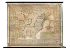
A handsome example of one of the Ensign firm's quintessential ornamental maps of the United States, which matched cartography with composite scenes of important images and portraits from the nation's history.
The map was issued in 1845 by Timothy and Edward Ensign. The engraving credit interestingly notes that the map was engraved on steel by J. Wells of Brooklyn, Long Island.
The map proper includes numerous insets, including the world, mountains and rivers of the world, over a dozen American cities, etc.
The images below the map show the Pilgrims landing in 1620, the Battle of Lexington, the Battle of Bunkers Hill, Washington's Farewell Address to the Army in 1783, and the Declaration of Independence.
The map is generally uninterested in the West. However, the Republic of Texas is shown in some detail, with Austin's Colony and many cities noted.
Though nominally aimed at "travellers", this map most likely ended up primarily on the walls of mid-19th-century American homes and businesses. Usually the traveler's guides took the form of folding maps in booklets, which were easily transported and consulted on the road.
![[ Atlas - Florida and Southern Canal Projects ] Travaux d'améliorations intérieurs projetés ou exécutés par le gouvernement général des États-Unis d'Amérique, de 1824 à 1831 [complete with:] Travaux d'améliorations intérieurs projetés ou exécutés... Atlas.](https://storage.googleapis.com/raremaps/img/small/85067.jpg)

![(Extremely Rare American View Book) Les Ports de l'Amerique [8 engraved prints of American Cities: Philadelphia, Boston, Savannah, Fredericksburg, Charlestown, Chesapeake Bay, Quebec, and Port Royal] Graveé d'apres le Tableau de Vernet.](https://storage.googleapis.com/raremaps/img/small/95381.jpg)