|
||

|

|
|

|
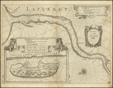
Beware the Maelstrom
Detailed and attractive sea chart of the North Atlantic, showing the cold waters bounded by Scandinavia, the north coast of Scotland, the Svalbard Archipelago, and the coast of Greenland. This navigational tool was published by Pieter Goos in Amsterdam in 1669 as part of an atlas of the world's seas.
The chart includes a detailed plan of the coastlines and shows soundings, towns, a compass rose, a cartouche, and a scale. Off the northwest coast of Norway is the dreaded Maelstrom, a whirlpool of Norse Legend. The discovery of an inlet in the East Greenland coastline by Gaal Hamkes in 1654 is marked.
Pieter Goos (ca. 1616-1675) was a Dutch map and chart maker, whose father, Abraham Goos (approx. 1590-1643), had already published numerous globes, land and sea maps together with Jodocus Hondius and Johannes Janssonius in Antwerp. Pieter gained recognition due to the publication of sea charts. He bought the copperplates of the famous guide book for sailors, De Lichtende Columne ofte Zeespiegel (Amsterdam 1644, 1649, 1650), from Anthonie Jacobsz. Goos published his own editions of this work in various languages, while adding his own maps. In 1666, he published his De Zee-Atlas ofte Water-Wereld, which is considered one of the best sea atlases of its time. Goos' sea charts came to dominate the Dutch market until the 1670s, when the Van Keulen family came to prominence.
![[Untitled Map of the Northern Hemisphere]](https://storage.googleapis.com/raremaps/img/small/18651.jpg)