This item has been sold, but you can enter your email address to be notified if another example becomes available.


|
||

|

|
|

|
Stock# 83645
Description
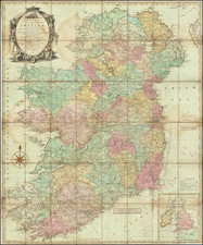
Attractive map of Ireland, showing counties, towns, rivers, lakes, islands, et cetera.
Robert Wilkinson was active in London as a cartographic publisher from 1785 to 1825. He produced a number of nice works, including a General Atlas and a re-issuance of Bowen & Kitchen's English Atlas, along with excellent large format separate maps.
Condition Description
Laid on linen.
![[Belfast and Carickfergus Lough] Plan der Gegend von Irrland, wo Ao. 1760 dens 18 Febr der See Avanturier u Capt. Thurot bey A gelandet und Carickfergus eingenomen auch bis Bellast vorge drungen, den 27 Febr: aber von den Engellandischen See Capitain Elliot . . .](https://storage.googleapis.com/raremaps/img/small/54174.jpg)
![[ Ireland ] Hiberniae Regnum tam in praecipuas Ultoniae, Connaciae, Lageniae, et Momoniae. . .](https://storage.googleapis.com/raremaps/img/small/78023.jpg)
![Ireland in Provinces and Counties [with] County Map of Scotland](https://storage.googleapis.com/raremaps/img/small/78014.jpg)