|
||

|

|
|

|
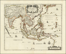
The first English map of Australia, which is derived directly from Thevenot's seminal map of 1663, showing the Dutch discoveries in the regiom.
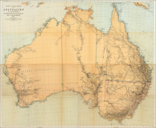
Bowen's map is the first English map of New Holland. The map appeared in the revised edition of John Harris' Complete Collection of Voyages. Bowen's map adds the Tropic of Capricorn and two texts: the upper block emphasizes that no assumptions have been made, so white space abounds between New Guinea and Carpentaria, and between the mainland, Tasmania and New Zealand; the lower text starts: It is impossible to conceive a Country that promises fairer from its situation, than this of Terra Australia; no longer incognita, as this map demonstrates…
The text includes reference to 'the best climate in the world', 'according to Coll. Purry'. Purry was a former employee of the Dutch East India Company interested in attracting the Dutch, French and English to settle in Nuyts' land.
Emanuel Bowen (1694?-1767) was a British engraver and print seller. He was most well-known for his atlases and county maps. Although he died in poverty, he was widely acknowledged for his expertise and was appointed as mapmaker to both George II of England and Louis XV of France. His business was carried on by his son, Thomas Bowen. He also trained many apprentices, two of whom became prominent mapmakers, Thomas Kitchin and Thomas Jeffreys.
![(Tasmania) A Chart of van Diemen's Land, the South Extremity of New Holland [on sheet with:] Continuation o fthe River from King George's Bay, on a larger Scale. with the Situation of the Ships Duke and Duchess, at Anchor.](https://storage.googleapis.com/raremaps/img/small/94750.jpg)