|
||

|

|
|

|
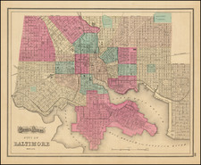
The Poppleton / Lucas Plan of Baltimore
Second state of Thomas Poppleton's finely engraved plan of Baltimore, published by Baltimore's most famous mapmaker, Fielding Lucas Jr.
Finely engraved plan of Baltimore, colored by wards.
The map includes a population table at the top left with populations by decade, beginning in 1790. Another note gives the number of avenues, streets, lanes and alleys. Developed blocks are shaded.
Papenfuse illustrates editions of 1822, 1836 and 1841. We also note an 1852 edition.
The Early Mapping of Baltimore
Founded in 1729, Baltimore began its real growth after the American Revolution. By 1800, it was the third largest city in the United States and one of the most prosperous. While the town had been mapped at the end of the 18th Century by two French mapmakers, Folie and Varle, it was not until the city's 1816 annexation of an additional 13 square miles of surrounding territory, that the city made a concerted effort to create a modern survey.
The commission hired Thomas Poppleton, who submitted his completed manuscripts in early 1822. In August 1822, Fielding Lucas Jr. issued Poppleton's survey as this Plan of the City of Baltimore, while Poppleton's full-scale plan was not published until the following year. The map was thereafter issued 3 times in successive decades and is perhaps the most important and influential map of the City published in the 19th Century.
Rarity
The map is quite rare on the market.
We note 1 example of the 1836 edition appearing in dealer catalog in the past 40 years (Old Print Gallery, 1990).
Fielding Lucas, Jr. (1781-1854) was a prominent American cartographer, engraver, artist, and public figure during the first half of the 19th century.
Lucas was born in Fredericksburg, Virginia and moved to Philadelphia as a teenager, before settling in Baltimore. There he launched a successful cartographic career. Lucas's first atlas was announced in early- to mid-1812, with production taking place between September 1812 and December of 1813, by which point the engravings were complete. Bound copies of the atlas -- A new and elegant general atlas: Containing maps of each of the United States -- were available early in the next year, beating Carey to market by about two months. Lucas later published A General Atlas Containing Distinct Maps Of all the known Countries in the World in the early 1820s.
![[ Washington DC / Virginia / Maryland / Delaware / New Jersey ] Washington Sectional Aeronautical Chart](https://storage.googleapis.com/raremaps/img/small/99620.jpg)