|
||

|

|
|

|
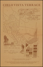
The Birth of Encino
Rare early promotional tract map of Encino Acres, in the San Fernando Valley.
The map is the earliest map of the future Encino, California and quite likely the earliest (and possibly the only) surviving map to depict "Encino Acres", the original subdivision of the area by William H. Hay in 1916. It includes a fine early photographic record of the California State Highway, which would later be re-named Ventura Blvd.
The map shows the area centered on the California State Highway (Ventura Blvd) from Haskell Avenue in the west to White Oak Avenue, covering the area south of today's Sepulveda Basin Recreational Area. The area marked as "Proposed Townsite" includes todayh's Los Encinos State Historic Park and extends north to Magnolia (Rita on this map).
The earliest advertising for Encino Acres dates back to January 1, 1916, in the Los Angeles Times, with advertisements beginning in earnest in late March 1916.
Encino
In 1769, Gasper de Portola, during his expedition across California on his way to Monterey, he was greeted by several hundred Grabielino Indians near Encino Springs (Encino being Spanish for “oak tree”).
In 1810, after the Mexican Revolution, Rancho Los Encinos was granted to the Grabielino Indians. At that time the rancho covered about seven square miles. However, after annexation of Mexico by the United States, the heirs of the orginal land grant lost ownership of the land and it eventually ended up in the hands of Vincent De La Ossa. De La Ossa built a sizeable adobe (which still stands), grazed 500 cattle, and employeed 20 ranch hands until he died in the 1860s. Title to the rancho was granted to the heirs of de la Osa on January 8, 1873. Shortly thereafter, title was transferred to a son-in-law, James Thompson. At the time, the Rancho consisted of 4,461 acres.
In 1875, Eugene Garnier and Phillipe Garnier bought the property and built the Encino Roadhouse which became a twice-a-day stop for both the Butterfield and the Overland Mail Stage between Los Angeles and San Francisco. They also diversified the ranch and raised sheep, wheat, and barley. In the early 20th Century the community of Encino began to be developed. In 1878, the property was sold for unpaid taxest to Gaston Oxarart. Following his death, on June 1, 1889, Simon Gless became the new owner, but shortly thereafter sold the property to his father in law, Domingo Amestoy.
By 1915, Amestoy's Ranch had been acquired by William H. Hay, a Los Angeles real estate developer and speculator, who subdivided the land into 5, 10 and 25 acre parcels.
William H. Hay
William H. Hay was born in Hamilton, Ontario, Canada in 1864. He came to Los Angeles in 1880. On April 8, 1888, he completed his naturalization as an American citizen..
For about sixteen years, Mr. Hay was associated with J. F. White in the real estate business at 4 East First Street in Los Angeles, first as a young associate an ultimately in a partnership, as White & Hay. For about ten years he was associated with C. E. Norton, the firm of Norton & Hay at 318 West Third Street. Their office, occupying the ground floor of the building there, was the best known real estate establishment of that time. After the death of Mr. Norton in 1911, Hay continued to operate as W.H. Hay.
Mr. Hay's earliest real estate interests included land in West Hollywood, a railroad tract adjoining the depot at San Bernardino and Marygold Acres adjoining the town of Rialto in San Bernardino County. By the 1915, he had acquired and later subdvided Encino Acres and and Crescent Heights, in West Hollywood.
Rarity
This is apparently the only surviving example.
It is likely that this was William H. Hay's copy of the map, as we acquired it in a collection which included a previously unknown map of Crescent Heights.
![[Hollywood / Los Angeles] Castle's Inc. Hollywood's Complete Camera Store](https://storage.googleapis.com/raremaps/img/small/73017.jpg)