This item has been sold, but you can enter your email address to be notified if another example becomes available.


|
||

|

|
|

|
Stock# 82731
Description
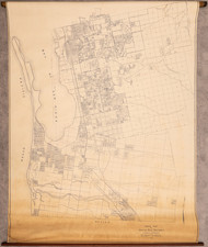
Scarce early road map of San Mateo County, prepared by the California State Automobile Association.
The map lists "paved highways and oiled roads" in red and "gravel or dirt roads" in blue.
Includes a list mileage tables from San Francisco to 8 major points in San Mateo County, primarily on via the Bayshore Highway and U.S. 101, but also referencing Skyline Blvd, Canada Road, and Coast Road.
Rarity
The map is quite scarce. It was apparently issued annually from about 1927 to 1944, however only Bancroft, Stanford, the California Historical Society and the University of Illinois seem to have copies 1 or more of the maps between this period.
Condition Description
Toned on one panel, with some extraneous pencil markings.
![Alameda County, California. Showing The Automobile Roads and Principal Points of Interest . . . [Livermore Valley Views]](https://storage.googleapis.com/raremaps/img/small/76961.jpg)
![(Lake Arrowhead Photographs) [Group of 4 Lake Arrowhead / Arlington Lodge Photos ]](https://storage.googleapis.com/raremaps/img/small/93199.jpg)